1950s Maps of Southampton, Massachusetts
Explore 6 historic maps of Southampton from the 1950s. These maps offer a rare glimpse into what life looked like during the 1950s — showing old roads, neighborhoods, homes, and landmarks that have changed or disappeared over time.
Whether you're researching your family's past, planning a metal detecting trip, or studying how Southampton's landscape evolved across the 1950s, these high-resolution maps are a powerful tool for exploring the history of this region.
- Focus on a specific era: All maps on this page are from the 1950s, giving you a focused view of this time period.
- See what’s changed: Compare century-old streets, trails, and buildings to today's modern landscape using overlays and satellite layers.
- Research with precision: Use these maps for genealogy, historical research, land use analysis, or educational projects.
- View, download, or print: Maps are fully viewable online in high resolution, and can be downloaded or printed for your own records.
Start exploring Southampton's history through authentic maps from the 1950s. This is your window into the past.
Southampton, MA maps
(6)- 1951 Map of Woronoco
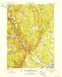 1951 Woronoco1951 Print · USGSThe Westfield River valley in the early 1950s shows a landscape of industrial hamlets and mountain trails. Genealogists can trace family landmarks like St Thomas Cem, Montgomery Ch, and the Wyben Sch nestled among the Berkshire foothills.3 unique versions available
 - 1955 Map of Westhampton, 1957 Print
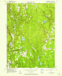 1955 Westhampton1957 Print · USGSHampshire County hill towns were entering a new era of conservation and forest regrowth in the mid-fifties. Researchers can trace old family burial grounds like Damon Cem, locate the Bisbee Mill site, and study the evolving boundary of the Huntington State Forest.2 unique versions available
 - 1956 Map of Albany, 1968 Print
 1956 Albany1968 Print · USGSThe industrial heart of the Northeast is revealed in the mid-1950s, from the Hudson Valley to the Connecticut River. Researchers can trace the legacy of the Quabbin Reservoir, locate Westover Air Force Base, or follow the Rutland RR through the Green Mountains.2 unique versions available
 - 1957 Map of Albany
 1957 Albany1957 Print · USGSThe Tri-State region and Connecticut River Valley are captured here during a period of significant postwar growth and infrastructure expansion. Genealogists and historians can trace the rail-and-river economy through landmarks like the Boston and Maine railroad, Quabbin Reservoir, and Westover Air Force Base.
 - 1958 Map of Mount Tom, 1960 Print
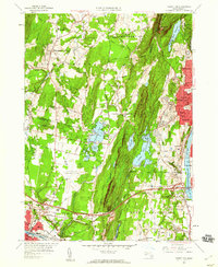 1958 Mount Tom1960 Print · USGSThe Pioneer Valley in the late fifties shows the post-war expansion of WESTFIELD and the rugged heights of East Mountain. Genealogists and local historians can trace several burial grounds like St Marys Cemetery, industrial landmarks including the Paper Mills, and mid-century recreation at the Drive-in Theater.2 unique versions available
 - 1959 Map of Albany
 1959 Albany1959 Print · USGSThe Hudson and Connecticut River valleys are captured here during the late fifties, showing the region's dense rail networks and massive water projects. Researchers can trace the New York State Thruway or locate local landmarks like Mt Greylock and the Quabbin Reservoir.
End of results
Showing maps 1-6 of 6
Top cities near Southampton
- Springfield historical maps
- Chicopee historical maps
- Enfield historical maps
- Westfield historical maps
- Holyoke historical maps
- Amherst historical maps
See more
Top neighborhoods of Southampton
- Swanson Corners historical maps
- Fomer historical maps
- Russellville historical maps
- Southampton Center Historic District historical maps
Frequently asked questions
- What are the different types of historical maps available for Southampton?
- What is the oldest map of Southampton?
- Where can I purchase historical maps of Southampton for my home or office?
- Where can I download high-res historical maps of Southampton?
- Are there historical topographic maps available for Southampton?
- Is there historical aerial imagery available for Southampton?
- Where are historical maps of Southampton sourced from?