1970s Maps of Southampton, Massachusetts
Explore 6 historic maps of Southampton from the 1970s. These maps offer a rare glimpse into what life looked like during the 1970s — showing old roads, neighborhoods, homes, and landmarks that have changed or disappeared over time.
Whether you're researching your family's past, planning a metal detecting trip, or studying how Southampton's landscape evolved across the 1970s, these high-resolution maps are a powerful tool for exploring the history of this region.
- Focus on a specific era: All maps on this page are from the 1970s, giving you a focused view of this time period.
- See what’s changed: Compare century-old streets, trails, and buildings to today's modern landscape using overlays and satellite layers.
- Research with precision: Use these maps for genealogy, historical research, land use analysis, or educational projects.
- View, download, or print: Maps are fully viewable online in high resolution, and can be downloaded or printed for your own records.
Start exploring Southampton's history through authentic maps from the 1970s. This is your window into the past.
Southampton, MA maps
(6)- 1972 Map of Westhampton, 1973 Print
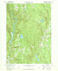 1972 Westhampton1973 Print · USGSHampshire County highland life and river management are preserved here in the early 1970s. Local researchers can trace family roots through Torrey Cem and Norwich Bridge Cem or locate former industrial sites like Bisbee Mill.2 unique versions available
 - 1972 Map of Mount Tom, 1974 Print
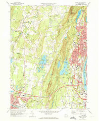 1972 Mount Tom1974 Print · USGSThe industrial corridor of the Connecticut River and the rugged peaks of the Mount Tom Range are captured here in the early 1970s. Trace local history through landmarks like the Dominican Monastery, Barnes Municipal Airport, and the vanished Drive-in Theater near the Hampton Ponds.3 unique versions available
 - 1975 Map of Mount Tom, 1981 Print
 1975 Mount Tom1981 Print · USGSThe Pioneer Valley in the mid-seventies is captured here via detailed aerial orthophotography. Researchers can trace the industrial layout of Holyoke by the Connecticut River or find local landmarks like Hampton Ponds and Mount Tom.
 - 1975 Map of Woronoco, 1981 Print
 1975 Woronoco1981 Print · USGSHampden County's river valleys and upland forests are captured in detail in the mid-seventies, showing the intersection of water resources and industry. Trace the historic footprints of Woronoco and Russell along the Westfield River or locate the sprawling Tighe Carmody Reservoir.
 - 1975 Map of Westhampton, 1981 Print
 1975 Westhampton1981 Print · USGSHampshire County’s wooded hills and river valleys are captured in mid-1970s aerial detail. Researchers can trace land use around Westhampton and follow the paths of the Westfield River or Pine Island Lake.
 - 1975 Map of Easthampton, 1981 Print
 1975 Easthampton1981 Print · USGSNorthampton and the central Pioneer Valley are documented here in the mid-seventies through detailed aerial photography. Genealogists and local historians can trace the exact 1975 footprints of settlements like Loudville, West Farms, and Easthampton.
End of results
Showing maps 1-6 of 6
Top cities near Southampton
- Springfield historical maps
- Chicopee historical maps
- Enfield historical maps
- Westfield historical maps
- Holyoke historical maps
- Amherst historical maps
See more
Top neighborhoods of Southampton
- Swanson Corners historical maps
- Fomer historical maps
- Russellville historical maps
- Southampton Center Historic District historical maps
Frequently asked questions
- What are the different types of historical maps available for Southampton?
- What is the oldest map of Southampton?
- Where can I purchase historical maps of Southampton for my home or office?
- Where can I download high-res historical maps of Southampton?
- Are there historical topographic maps available for Southampton?
- Is there historical aerial imagery available for Southampton?
- Where are historical maps of Southampton sourced from?