1960s Maps of Southampton, Massachusetts
Explore 3 historic maps of Southampton from the 1960s. These maps offer a rare glimpse into what life looked like during the 1960s — showing old roads, neighborhoods, homes, and landmarks that have changed or disappeared over time.
Whether you're researching your family's past, planning a metal detecting trip, or studying how Southampton's landscape evolved across the 1960s, these high-resolution maps are a powerful tool for exploring the history of this region.
- Focus on a specific era: All maps on this page are from the 1960s, giving you a focused view of this time period.
- See what’s changed: Compare century-old streets, trails, and buildings to today's modern landscape using overlays and satellite layers.
- Research with precision: Use these maps for genealogy, historical research, land use analysis, or educational projects.
- View, download, or print: Maps are fully viewable online in high resolution, and can be downloaded or printed for your own records.
Start exploring Southampton's history through authentic maps from the 1960s. This is your window into the past.
Southampton, MA maps
(3)- 1962 Map of Albany
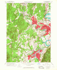
 1962 Albany1962 Print · USGSThe Hudson and Connecticut River valleys meet the Green Mountains and Berkshires in this mid-century overview of the Northeast. Genealogists and historians can trace the industrial hearts of Albany and Springfield or locate features like Quabbin Reservoir and Westover Air Force Base.
 - 1964 Map of Easthampton, 1967 Print
 1964 Easthampton1967 Print · USGSNorthampton and Easthampton are shown at a peak of mid-century development, framed by the Connecticut River and the Sawmill Hills. Genealogists and historians can trace institutional landmarks like Smith College, Williston Academy, and St Marys Cem.3 unique versions available
 - 1967 Map of Woronoco, 1970 Print
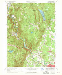 1967 Woronoco1970 Print · USGSHampden County's river-driven industry and upland forests are documented here in the late sixties, showing the vital transit corridor along the Westfield River. Genealogists and local historians can locate early burial sites like St Thomas Cem and industrial landmarks such as the mills at Woronoco or the Wyben Chapel.2 unique versions available
End of results
Showing maps 1-3 of 3
Top cities near Southampton
- Springfield historical maps
- Chicopee historical maps
- Enfield historical maps
- Westfield historical maps
- Holyoke historical maps
- Amherst historical maps
See more
Top neighborhoods of Southampton
- Swanson Corners historical maps
- Fomer historical maps
- Russellville historical maps
- Southampton Center Historic District historical maps
Frequently asked questions
- What are the different types of historical maps available for Southampton?
- What is the oldest map of Southampton?
- Where can I purchase historical maps of Southampton for my home or office?
- Where can I download high-res historical maps of Southampton?
- Are there historical topographic maps available for Southampton?
- Is there historical aerial imagery available for Southampton?
- Where are historical maps of Southampton sourced from?