1960s Maps of North Reading, Massachusetts
Explore 3 historic maps of North Reading from the 1960s. These maps offer a rare glimpse into what life looked like during the 1960s — showing old roads, neighborhoods, homes, and landmarks that have changed or disappeared over time.
Whether you're researching your family's past, planning a metal detecting trip, or studying how North Reading's landscape evolved across the 1960s, these high-resolution maps are a powerful tool for exploring the history of this region.
- Focus on a specific era: All maps on this page are from the 1960s, giving you a focused view of this time period.
- See what’s changed: Compare century-old streets, trails, and buildings to today's modern landscape using overlays and satellite layers.
- Research with precision: Use these maps for genealogy, historical research, land use analysis, or educational projects.
- View, download, or print: Maps are fully viewable online in high resolution, and can be downloaded or printed for your own records.
Start exploring North Reading's history through authentic maps from the 1960s. This is your window into the past.
North Reading, MA maps
(3)- 1961 Map of Boston
 1961 Boston1961 Print · USGSThe Massachusetts coastline and its industrial interior are detailed here in the mid-twentieth century, from the Monadnock highlands to Cape Cod. Researchers can trace the rail routes of the Boston and Maine or locate landmarks like Fort Devens and the Wachusett Reservoir.2 unique versions available
 - 1965 Map of Wilmington, 1968 Print
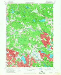
 1965 Wilmington1968 Print · USGSWilmington and Tewksbury are captured in the mid-sixties as post-war suburban growth begins to surround established institutions and rail lines. Researchers can trace family history through the Tewksbury State Hospital, Wildwood Cemetery, and local schools like North Street Sch.2 unique versions available
 - 1966 Map of Reading, 1968 Print
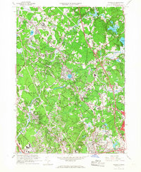
 1966 Reading1968 Print · USGSMiddlesex and Essex counties are shown here in the mid-sixties, a period of notable suburban growth surrounding the historic towns of Reading and Wakefield. Researchers can trace family sites near Quannapowitt Lake, the Puritan Lawn Memorial Park, or the sprawling Harold Parker State Forest.2 unique versions available
End of results
Showing maps 1-3 of 3
Top cities near North Reading
- Boston historical maps
- Lowell historical maps
- Cambridge historical maps
- Lynn historical maps
- Newton historical maps
- Lawrence historical maps
See more
Top neighborhoods of North Reading
Frequently asked questions
- What are the different types of historical maps available for North Reading?
- What is the oldest map of North Reading?
- Where can I purchase historical maps of North Reading for my home or office?
- Where can I download high-res historical maps of North Reading?
- Are there historical topographic maps available for North Reading?
- Is there historical aerial imagery available for North Reading?
- Where are historical maps of North Reading sourced from?