1970s Maps of Town Pasture, Massachusetts
Explore 2 historic maps of Town Pasture from the 1970s. These maps offer a rare glimpse into what life looked like during the 1970s — showing old roads, neighborhoods, homes, and landmarks that have changed or disappeared over time.
Whether you're researching your family's past, planning a metal detecting trip, or studying how Town Pasture's landscape evolved across the 1970s, these high-resolution maps are a powerful tool for exploring the history of this region.
- Focus on a specific era: All maps on this page are from the 1970s, giving you a focused view of this time period.
- See what’s changed: Compare century-old streets, trails, and buildings to today's modern landscape using overlays and satellite layers.
- Research with precision: Use these maps for genealogy, historical research, land use analysis, or educational projects.
- View, download, or print: Maps are fully viewable online in high resolution, and can be downloaded or printed for your own records.
Start exploring Town Pasture's history through authentic maps from the 1970s. This is your window into the past.
Town Pasture, MA maps
(2)- 1972 Map of Nantucket, 1973 Print
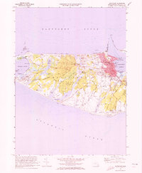 1972 Nantucket1973 Print · USGSNantucket Island's coastal and village life is captured here in the early seventies, from the busy wharves to the quiet ponds of the interior. Researchers can trace historic family connections at the Old Settlers Graves, Brant Pt Lighthouse, and Academy Hill Sch.4 unique versions available
 - 1977 Map of Nantucket, 1981 Print
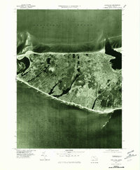 1977 Nantucket1981 Print · USGSNantucket Island in the late 1970s is shown here through detailed aerial photography, offering a literal view of the coastal landscape and town. Researchers can trace development patterns from the harbor at Nantucket to the outposts of Madaket and Surfside.
End of results
Showing maps 1-2 of 2
Top cities near Town Pasture
Frequently asked questions
- What are the different types of historical maps available for Town Pasture?
- What is the oldest map of Town Pasture?
- Where can I purchase historical maps of Town Pasture for my home or office?
- Where can I download high-res historical maps of Town Pasture?
- Are there historical topographic maps available for Town Pasture?
- Is there historical aerial imagery available for Town Pasture?
- Where are historical maps of Town Pasture sourced from?