1970s Maps of Needham, Massachusetts
Explore 4 historic maps of Needham from the 1970s. These maps offer a rare glimpse into what life looked like during the 1970s — showing old roads, neighborhoods, homes, and landmarks that have changed or disappeared over time.
Whether you're researching your family's past, planning a metal detecting trip, or studying how Needham's landscape evolved across the 1970s, these high-resolution maps are a powerful tool for exploring the history of this region.
- Focus on a specific era: All maps on this page are from the 1970s, giving you a focused view of this time period.
- See what’s changed: Compare century-old streets, trails, and buildings to today's modern landscape using overlays and satellite layers.
- Research with precision: Use these maps for genealogy, historical research, land use analysis, or educational projects.
- View, download, or print: Maps are fully viewable online in high resolution, and can be downloaded or printed for your own records.
Start exploring Needham's history through authentic maps from the 1970s. This is your window into the past.
Needham, MA maps
(4)- 1970 Map of Natick, 1972 Print
 1970 Natick1972 Print · USGSSuburban Boston expands through Middlesex and Norfolk counties in the 1970s, showcasing a landscape of elite universities and crucial water infrastructure. Researchers can trace the Cochituate Aqueduct and locate landmarks like Wellesley College or the Natick Laboratories (U S Army).2 unique versions available
 - 1970 Map of Newton, 1973 Print
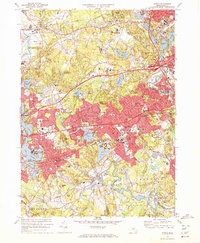
 1970 Newton1973 Print · USGSThe western suburbs of Boston reached a peak of mid-century density during this era of highway and rail expansion. Researchers can trace historic parish boundaries and burial sites like Newton Cemetery or locate landmarks like Boston College and the Arnold Arboretum.2 unique versions available
 - 1977 Map of Newton, 1980 Print
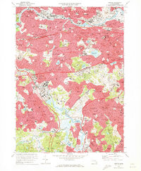
 1977 Newton1980 Print · USGSThe western suburbs of Boston are revealed in detail during the late seventies, showing the dense development of these historic townships. Trace the winding Charles River through Newton, Brookline, and Watertown to see the region's layout.
 - 1977 Map of Natick, 1981 Print
 1977 Natick1981 Print · USGSSuburban development and ancient river courses meet in this late-1970s aerial survey of Middlesex County. Genealogists and historians can trace the mid-century growth of Natick and Wellesley alongside the winding Charles River.
End of results
Showing maps 1-4 of 4
Top cities near Needham
- Boston historical maps
- Cambridge historical maps
- Brockton historical maps
- Quincy historical maps
- Newton historical maps
- Somerville historical maps
See more
Top neighborhoods of Needham
- Charles River Village historical maps
- Needham Heights historical maps
- Birds Hill historical maps
- Eliot Triangle historical maps
- Greendale Village historical maps
- Babson Park historical maps
See more
Frequently asked questions
- What are the different types of historical maps available for Needham?
- What is the oldest map of Needham?
- Where can I purchase historical maps of Needham for my home or office?
- Where can I download high-res historical maps of Needham?
- Are there historical topographic maps available for Needham?
- Is there historical aerial imagery available for Needham?
- Where are historical maps of Needham sourced from?