1930s Maps of Kingston, Massachusetts
Explore 4 historic maps of Kingston from the 1930s. These maps offer a rare glimpse into what life looked like during the 1930s — showing old roads, neighborhoods, homes, and landmarks that have changed or disappeared over time.
Whether you're researching your family's past, planning a metal detecting trip, or studying how Kingston's landscape evolved across the 1930s, these high-resolution maps are a powerful tool for exploring the history of this region.
- Focus on a specific era: All maps on this page are from the 1930s, giving you a focused view of this time period.
- See what’s changed: Compare century-old streets, trails, and buildings to today's modern landscape using overlays and satellite layers.
- Research with precision: Use these maps for genealogy, historical research, land use analysis, or educational projects.
- View, download, or print: Maps are fully viewable online in high resolution, and can be downloaded or printed for your own records.
Start exploring Kingston's history through authentic maps from the 1930s. This is your window into the past.
Kingston, MA maps
(4)- 1934 Map of Plymouth
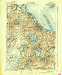
 1934 Plymouth1934 Print · USGSThe Massachusetts coast near the height of its cranberry-growing era is captured in this mid-1930s survey of the shoreline and its glacial interior. Genealogists and historians can trace the legacy of the region through landmarks like Plymouth Rock, the Plymouth Cem, and numerous family-named sites such as Bernard Shaw Bog.
 - 1935 Map of Hanover
 1935 Hanover1935 Print · USGSThe northern Plymouth County ponds and woodlands are shown here in the mid-1930s as industry and early leisure began to reshape the landscape. Genealogists can trace family plots at Magoun Cem and Pine Grove Cemetery, or locate historic hubs like Schoosett and Curtis Crossing.
 - 1937 Map of Plympton
 1937 Plympton1937 Print · USGSPlymouth County in the late 1930s is revealed here as a landscape of cranberry bogs and rural school districts. Genealogists can trace family connections through the Lakenham Cem or locate the old Soule Sch and Thomastown Sch.
 - 1939 Map of Plymouth
 1939 Plymouth1939 Print · USGSThe Plymouth coast and its pond-studded interior are captured here in the late 1930s. Researchers can trace the waterfront around Plymouth Rock or locate regional sites like Fort Standish, Jabez Corner, and Chiltonville.4 unique versions available
End of results
Showing maps 1-4 of 4
Top cities near Kingston
- Plymouth historical maps
- Weymouth historical maps
- Braintree historical maps
- Bridgewater historical maps
- Marshfield historical maps
- Hingham historical maps
See more
Top neighborhoods of Kingston
- Miramar historical maps
- Silver Lake historical maps
- Rocky Nook Park historical maps
- Kingston Shores historical maps
- Rocky Nook Point historical maps
- Camp Mishannock historical maps
See more
Frequently asked questions
- What are the different types of historical maps available for Kingston?
- What is the oldest map of Kingston?
- Where can I purchase historical maps of Kingston for my home or office?
- Where can I download high-res historical maps of Kingston?
- Are there historical topographic maps available for Kingston?
- Is there historical aerial imagery available for Kingston?
- Where are historical maps of Kingston sourced from?