1900s (20th Century) Maps of Harvard, Massachusetts
Explore 35 historic maps of Harvard from the 1900s (20th Century). These maps offer a rare glimpse into what life looked like during the 1900s — showing old roads, neighborhoods, homes, and landmarks that have changed or disappeared over time.
Whether you're researching your family's past, planning a metal detecting trip, or studying how Harvard's landscape evolved across the 1900s, these high-resolution maps are a powerful tool for exploring the history of this region.
- Focus on a specific era: All maps on this page are from the 1900s, giving you a focused view of this time period.
- See what’s changed: Compare century-old streets, trails, and buildings to today's modern landscape using overlays and satellite layers.
- Research with precision: Use these maps for genealogy, historical research, land use analysis, or educational projects.
- View, download, or print: Maps are fully viewable online in high resolution, and can be downloaded or printed for your own records.
Start exploring Harvard's history through authentic maps from the 1900s. This is your window into the past.
Harvard, MA maps
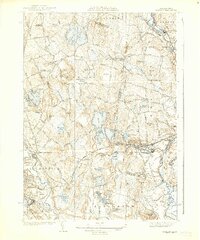
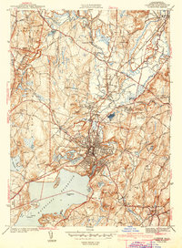
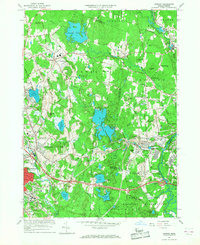
(35)- 1908 Map of Quinsigamond
 1908 Quinsigamond1908 Print · USGSCentral Massachusetts and its bordering states are seen here in the early twentieth century as industry and transit reshaped the Blackstone Valley. Genealogists and historians can trace the early footprints of Worcester, the expansion of the Wachusett Reservoir, and rail lines like the Boston and Albany Railroad.3 unique versions available
 - 1935 Map of Ayer
 1935 Ayer1935 Print · USGSThe intersection of Middlesex and Worcester counties in the mid-1930s reveals a landscape of military bases, historic academies, and industrial ponds. Researchers can trace the layout of Fort Devens, the grounds of the Groton School, and the unique settlement at Shaker Village.
 - 1935 Map of Groton
 1935 Groton1935 Print · USGSCrossing the New Hampshire border in the 1930s, this area was a bustling hub of rail transport and riverside industry. Researchers can trace the legacy of communal life at Shaker Village, locate the campus of Groton School, or follow the lines of the Boston and Maine RR through towns like Pepperell and Shirley.
 - 1935 Map of Shirley
 1935 Shirley1935 Print · USGSThe Nashua River valley during the mid-1930s shows a region defined by its rail connections and hilltop villages. Genealogists can trace family sites near Shirley Center, the Industrial School, and cemeteries like St Leo Cem.3 unique versions available
 - 1936 Map of Groton
 1936 Groton1936 Print · USGSNorthern Middlesex County and southern New Hampshire appear here in the mid-1930s, showing a landscape shaped by river power and a dense rail network. Researchers can trace historic sites like the Shaker Village and Groton School, or locate old depots at Townsend Harbor and Ayer.3 unique versions available
 - 1939 Map of Ayer
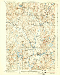
 1939 Ayer1939 Print · USGSMiddlesex County in the late 1930s is a hub of military activity and historic settlements at the crossroads of the rail. Trace ancestral roots at Shaker Village, Pingryville, or the expansive grounds of Fort Devens.6 unique versions available
 - 1939 Map of Shirley
 1939 Shirley1939 Print · USGSWorcester and Middlesex counties are shown in the late thirties, when rail lines and river valleys defined the region's industrial and social life. Genealogists and researchers can locate the Industrial School, family-named landmarks like Kezar Hill, and numerous cemeteries including St Cecelia Cemetery.3 unique versions available
 - 1943 Map of Clinton
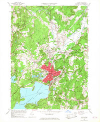
 1943 Clinton1943 Print · USGSMid-century Worcester County is defined here by the massive Wachusett Reservoir and the busy industrial corridor of the Nashua River. Genealogists and historians can trace the foundations of CLINTON, the grounds of Atlantic Union College, and wartime boundaries of Fort Devens.3 unique versions available
 - 1943 Map of Fitchburg
 1943 Fitchburg1943 Print · USGSSouthern New Hampshire and northern Massachusetts are captured during the war years, showing a landscape of river-powered mill towns and mountain trails. You can trace family roots in Peterboro, locate the historic Groton School, or study the rail lines of the Boston & Maine RR.
 - 1943 Map of Quinsigamond
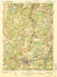
 1943 Quinsigamond1943 Print · USGSCentral Massachusetts and its bordering states appear here during the Second World War as a powerhouse of rail infrastructure and public institutions. Researchers can trace the legacy of the region through landmarks like Grafton State Hospital, the Wachusett Reservoir, and the deep industrial roots of the Blackstone River.
 - 1943 Map of Hudson
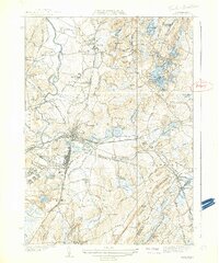
 1943 Hudson1943 Print · USGSThe townships of Middlesex and Worcester Counties are shown here during the early 1940s as rural crossroads began to evolve. Genealogists and local historians can trace family-named sites like Potash Hill, find the Old Quaker Ch, and locate old schoolhouses like Emerson Sch.4 unique versions available
 - 1948 Map of Boston
 1948 Boston1948 Print · USGSEastern Massachusetts and southern New Hampshire appear at an industrial peak in the late 1940s, just as suburban growth began to accelerate. Genealogists and historians can trace rail lines like the Boston and Albany RR or locate coastal landmarks like Graves Lighthouse and Fort Devens.2 unique versions available
 - 1949 Map of Shirley
 1949 Shirley1949 Print · USGSPost-war central Massachusetts reveals its military and rural character as Fort Devens expands near the Nashua River. Genealogists and historians can trace the Shaker Cemetery, the Industrial School, and the legacy of the Boston and Maine Railroad.
 - 1950 Map of Clinton, 1952 Print
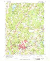
 1950 Clinton1952 Print · USGSMid-century Worcester County comes to life here, showing the busy industrial valley of the Nashua River and the expanding Wachusett Reservoir shoreline. Trace the footprints of South Lancaster institutions and vanished landmarks like the Bolton Airport and Ponakin Mill.4 unique versions available
 - 1950 Map of Hudson, 1958 Print
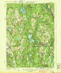
 1950 Hudson1958 Print · USGSMid-century Middlesex and Worcester counties come to life as the industrial Assabet River valley meets rural Bolton and Stow. Trace the Boston and Maine Railroad past Gleasondale Sta or find family roots at Old Quaker Cem and Bromfield Academy.3 unique versions available
 - 1950 Map of Shirley, 1958 Print
 1950 Shirley1958 Print · USGSMid-century development spreads through the Worcester and Middlesex county lines during this era of growth. Genealogists and local historians can trace family plots in St Cecelia Cemetery or locate old school sites like the White Sch and the Industrial School.
 - 1950 Map of Ayer, 1958 Print
 1950 Ayer1958 Print · USGSMiddlesex and Worcester counties are shown here at mid-century, highlighting the massive expansion of the Fort Devens military footprint. Researchers can trace the layout of Shaker Village, find the Harvard University Observatory, and locate the Groton School.
 - 1955 Map of Shirley
 1955 Shirley1955 Print · USGSCentral Massachusetts at mid-century shows the significant expansion of military life and rail transit near the Nashua River. Trace local family roots at St Leo Cem or explore the extensive footprint of Fort Devens Military Reservation and the Boston and Maine Railroad.2 unique versions available
 - 1956 Map of Boston, 1967 Print
 1956 Boston1967 Print · USGSThe Massachusetts coastline and industrial interior are seen here during the mid-century peak of suburban and highway expansion. Researchers can trace historic harbor defenses like Fort Revere, local landmarks such as Faneuil Hall, and the vast Parker River National Wildlife Refuge.6 unique versions available
 - 1958 Map of Boston
 1958 Boston1958 Print · USGSEastern Massachusetts and southern New Hampshire are shown at the height of the industrial era, before the full expansion of the interstate system. Trace coastal defenses at Fort Warren, historic rail lines like the Boston and Maine, and the development of the Mass. 128 corridor.2 unique versions available
 - 1961 Map of Boston
 1961 Boston1961 Print · USGSThe Massachusetts coastline and its industrial interior are detailed here in the mid-twentieth century, from the Monadnock highlands to Cape Cod. Researchers can trace the rail routes of the Boston and Maine or locate landmarks like Fort Devens and the Wachusett Reservoir.2 unique versions available
 - 1965 Map of Shirley, 1968 Print
 1965 Shirley1968 Print · USGSShirley and the surrounding Worcester County uplands are captured here in the mid-sixties as military operations and industrial growth intersected. Genealogists and historians can trace the footprint of Fort Devens, the State Industrial Sch for Boys, and the village layout of Shirley Center.3 unique versions available
 - 1965 Map of Clinton, 1968 Print
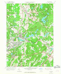
 1965 Clinton1968 Print · USGSClinton and the Nashua River valley are shown here in the mid-sixties as the region balanced its industrial past with expanding infrastructure. Researchers can locate the Wachusett Aqueduct, the campus of Atlantic Union College, and numerous historic burial grounds like Old Settlers Cem.2 unique versions available
 - 1966 Map of Hudson, 1968 Print
 1966 Hudson1968 Print · USGSMiddlesex and Worcester counties meet here in the mid-sixties, showing the industrial pulse of Hudson and the surrounding rural townships. Researchers can trace family history through a dozen named burial grounds like St Michaels Cem or locate old neighborhood schools and rail stops along the Boston and Maine Railroad.2 unique versions available
 - 1966 Map of Ayer, 1968 Print
 1966 Ayer1968 Print · USGSMiddlesex County in the mid-sixties reveals a landscape of massive military installations and storied academic institutions. Researchers can locate Shaker Village, trace the Boston and Maine rail lines, and find landmarks like the Harvard University Observatory.3 unique versions available
Showing maps 1-25 of 35
Top cities near Harvard
- Worcester historical maps
- Lowell historical maps
- Nashua historical maps
- Framingham historical maps
- Leominster historical maps
- Fitchburg historical maps
See more
Top neighborhoods of Harvard
- Devens historical maps
- Still River historical maps
- Camp Green Eyrie historical maps
- Harvard Shaker Village Historic District historical maps
- Shaker Village historical maps
- Center of Town historical maps
Frequently asked questions
- What are the different types of historical maps available for Harvard?
- What is the oldest map of Harvard?
- Where can I purchase historical maps of Harvard for my home or office?
- Where can I download high-res historical maps of Harvard?
- Are there historical topographic maps available for Harvard?
- Is there historical aerial imagery available for Harvard?
- Where are historical maps of Harvard sourced from?