1900s (20th Century) Maps of Hopedale, Massachusetts
Explore 32 historic maps of Hopedale from the 1900s (20th Century). These maps offer a rare glimpse into what life looked like during the 1900s — showing old roads, neighborhoods, homes, and landmarks that have changed or disappeared over time.
Whether you're researching your family's past, planning a metal detecting trip, or studying how Hopedale's landscape evolved across the 1900s, these high-resolution maps are a powerful tool for exploring the history of this region.
- Focus on a specific era: All maps on this page are from the 1900s, giving you a focused view of this time period.
- See what’s changed: Compare century-old streets, trails, and buildings to today's modern landscape using overlays and satellite layers.
- Research with precision: Use these maps for genealogy, historical research, land use analysis, or educational projects.
- View, download, or print: Maps are fully viewable online in high resolution, and can be downloaded or printed for your own records.
Start exploring Hopedale's history through authentic maps from the 1900s. This is your window into the past.
Hopedale, MA maps
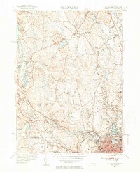
(32)- 1900 Map of Blackstone
 1900 Blackstone1900 Print · USGSThe Blackstone Valley was a bustling manufacturing corridor when this late Victorian-era survey was published. Genealogists and historians can trace the industrial mill villages along the Blackstone River, including Whitinsville, Manchaug, and Millville.7 unique versions available
 - 1908 Map of Quinsigamond
 1908 Quinsigamond1908 Print · USGSCentral Massachusetts and its bordering states are seen here in the early twentieth century as industry and transit reshaped the Blackstone Valley. Genealogists and historians can trace the early footprints of Worcester, the expansion of the Wachusett Reservoir, and rail lines like the Boston and Albany Railroad.3 unique versions available
 - 1919 Map of Franklin
 1919 Franklin1919 Print · USGSEastern Massachusetts at the end of the Great War was a landscape defined by its river-powered mill towns and expanding rail corridors. Genealogists and local historians can trace family roots through industrial hamlets like City Mills, Unionville, and Sheldonville.2 unique versions available
 - 1919 Map of Blackstone
 1919 Blackstone1919 Print · USGSThe Blackstone Valley at the end of the Great War was a dense network of industrial villages and crucial rail junctions. Genealogists and historians can trace the family-named landmarks of the era, from Saundersville and Linwood to the heights of Dorothy Hill.2 unique versions available
 - 1921 Map of Franklin, 1942 Print
 1921 Franklin1942 Print · USGSThe Charles River valley was a network of bustling rail junctions and mill villages in the years following the Great War. You can trace the development of towns like Franklin and Medway or locate smaller centers such as City Mills and Unionville.
 - 1939 Map of Franklin, 1942 Print
 1939 Franklin1942 Print · USGSThe Massachusetts and Rhode Island borderlands are captured here just before the war, showing the industrial nodes of Franklin and Woonsocket. Genealogists can trace family roots at Ballow Meetinghouse, St Marys Cem, and the old campus of Dean Academy.
 - 1940 Map of Franklin
 1940 Franklin1940 Print · USGSFranklin and the surrounding border towns of Norfolk County are shown here just before the mid-century. Genealogists can locate specific sites like Dean Academy, St Johns Cem, and the old rail corridors of the New York New Haven and Hartford.2 unique versions available
 - 1943 Map of Boston
 1943 Boston1943 Print · USGSGreater Boston and its southern suburbs appear here during the mobilization of the early 1940s. Genealogists and historians can trace the early footprints of Commonwealth Airport, military sites like Fort Winthrop, and local institutions such as Pondville State Hospital.
 - 1943 Map of Quinsigamond
 1943 Quinsigamond1943 Print · USGSCentral Massachusetts and its bordering states appear here during the Second World War as a powerhouse of rail infrastructure and public institutions. Researchers can trace the legacy of the region through landmarks like Grafton State Hospital, the Wachusett Reservoir, and the deep industrial roots of the Blackstone River.
 - 1944 Map of Blackstone
 1944 Blackstone1944 Print · USGSThe Blackstone River valley during the mid-forties shows a bustling landscape of industrial mill towns and upland farms along the state line. Genealogists can locate family landmarks like the Chestnut Hill Meeting House, Bicknell Cem, and the Elmdale Sch.5 unique versions available
 - 1945 Map of Franklin, 1956 Print
 1945 Franklin1956 Print · USGSFranklin and the surrounding borderlands of Massachusetts and Rhode Island are captured here during a period of steady post-war growth. Researchers can trace historic family landmarks such as Ballow Meetinghouse, Dean Academy, and the St Johns Cem.
 - 1946 Map of Franklin
 1946 Franklin1946 Print · USGSNorfolk County and the Massachusetts-Rhode Island borderlands are documented here at the end of World War II. Researchers can locate family sites at St Johns Cem, trace the rail lines of the New York New Haven and Hartford Railroad, or find old meeting houses like Ballow Meetinghouse.3 unique versions available
 - 1946 Map of Milford
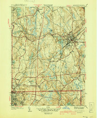
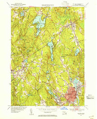
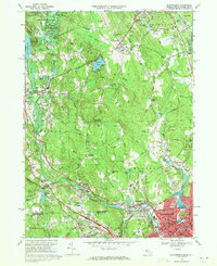
 1946 Milford1946 Print · USGSMid-century Worcester County comes to life as the industrial and rail hubs of Milford and Hopedale thrive before the highway era. Genealogists and historians can trace rail lines like the New York Central and locate sites like the County Home or St Marys Cem.2 unique versions available
 - 1948 Map of Boston
 1948 Boston1948 Print · USGSEastern Massachusetts and southern New Hampshire appear at an industrial peak in the late 1940s, just as suburban growth began to accelerate. Genealogists and historians can trace rail lines like the Boston and Albany RR or locate coastal landmarks like Graves Lighthouse and Fort Devens.2 unique versions available
 - 1948 Map of Blackstone
 1948 Blackstone1948 Print · USGSThe Blackstone River valley comes alive in this post-war survey of the Massachusetts and Rhode Island borderlands. Genealogists can trace family roots through the Chestnut Hill Meeting House, Precious Blood Cem, and early schools like Elmdale Sch.
 - 1953 Map of Blackstone, 1954 Print
 1953 Blackstone1954 Print · USGSThe industrial corridor between Mendon and Woonsocket comes alive in this mid-century survey of the Blackstone River valley. Local historians can trace the paths of the New York New Haven and Hartford railroad through family landmarks like the Chestnut Hill Meeting House and Draper Airfield.4 unique versions available
 - 1953 Map of Milford, 1955 Print
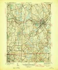
 1953 Milford1955 Print · USGSMilford and Hopkinton are shown in the early fifties, a time when rail lines still connected these growing Worcester County towns. Genealogists and local historians can locate St Marys Cath, trace the New York New Haven and Hartford RR, and explore family plots at Evergreen Cem.4 unique versions available
 - 1956 Map of Boston, 1967 Print
 1956 Boston1967 Print · USGSThe Massachusetts coastline and industrial interior are seen here during the mid-century peak of suburban and highway expansion. Researchers can trace historic harbor defenses like Fort Revere, local landmarks such as Faneuil Hall, and the vast Parker River National Wildlife Refuge.6 unique versions available
 - 1958 Map of Boston
 1958 Boston1958 Print · USGSEastern Massachusetts and southern New Hampshire are shown at the height of the industrial era, before the full expansion of the interstate system. Trace coastal defenses at Fort Warren, historic rail lines like the Boston and Maine, and the development of the Mass. 128 corridor.2 unique versions available
 - 1961 Map of Boston
 1961 Boston1961 Print · USGSThe Massachusetts coastline and its industrial interior are detailed here in the mid-twentieth century, from the Monadnock highlands to Cape Cod. Researchers can trace the rail routes of the Boston and Maine or locate landmarks like Fort Devens and the Wachusett Reservoir.2 unique versions available
 - 1964 Map of Franklin, 1965 Print
 1964 Franklin1965 Print · USGSThe borderlands of Massachusetts and Rhode Island are shown in the mid-1960s as suburban growth met traditional industry. Trace family sites like Ballou Cem, find old neighborhood names like Sheldonville, or locate the Dean Jr College campus.4 unique versions available
 - 1965 Map of Franklin, 1979 Print
 1965 Franklin1979 Print · USGSThe Massachusetts and Rhode Island border country comes into focus in the mid-twentieth century, showing the growing suburbs around Bellingham and Unionville. Genealogists and historians can trace family plots at Ballou Cem and locate institutional landmarks like Dean Junior College and St Marys Abbey.
 - 1968 Map of Milford, 1971 Print
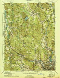
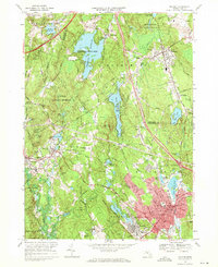 1968 Milford1971 Print · USGSMid-century Massachusetts comes to life in this survey of the Milford and Hopedale area during a period of industrial maturity. Researchers can trace family roots through numerous sites like St Marys Cem, Pratt Pond, and Upton.2 unique versions available
 - 1969 Map of Blackstone, 1971 Print
 1969 Blackstone1971 Print · USGSThe Blackstone River valley comes alive in the late sixties, showing the industrial heart of the Massachusetts and Rhode Island border. Researchers can trace ancestral roots through dozens of local sites, from the Chestnut Hill Meeting House Cem to the storied streets of Woonsocket and Millville.6 unique versions available
 - 1977 Map of Milford, 1980 Print
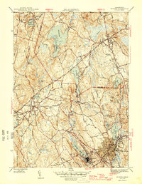
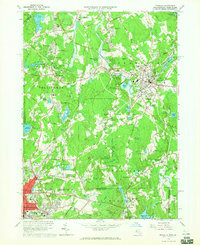
 1977 Milford1980 Print · USGSIn the late 1970s, the Blackstone Valley corridor was undergoing a period of rapid suburban growth. Genealogists and historians can trace the street-level development of Milford and Hopedale, or study the landscape around North Pond.
Showing maps 1-25 of 32
Top cities near Hopedale
- Worcester historical maps
- Framingham historical maps
- Attleboro historical maps
- Woonsocket historical maps
- Marlborough historical maps
- Cumberland historical maps
See more
Top neighborhoods of Hopedale
Frequently asked questions
- What are the different types of historical maps available for Hopedale?
- What is the oldest map of Hopedale?
- Where can I purchase historical maps of Hopedale for my home or office?
- Where can I download high-res historical maps of Hopedale?
- Are there historical topographic maps available for Hopedale?
- Is there historical aerial imagery available for Hopedale?
- Where are historical maps of Hopedale sourced from?