1970s Maps of Petersham, Massachusetts
Explore 10 historic maps of Petersham from the 1970s. These maps offer a rare glimpse into what life looked like during the 1970s — showing old roads, neighborhoods, homes, and landmarks that have changed or disappeared over time.
Whether you're researching your family's past, planning a metal detecting trip, or studying how Petersham's landscape evolved across the 1970s, these high-resolution maps are a powerful tool for exploring the history of this region.
- Focus on a specific era: All maps on this page are from the 1970s, giving you a focused view of this time period.
- See what’s changed: Compare century-old streets, trails, and buildings to today's modern landscape using overlays and satellite layers.
- Research with precision: Use these maps for genealogy, historical research, land use analysis, or educational projects.
- View, download, or print: Maps are fully viewable online in high resolution, and can be downloaded or printed for your own records.
Start exploring Petersham's history through authentic maps from the 1970s. This is your window into the past.
Petersham, MA maps
(10)- 1970 Map of Athol, 1972 Print
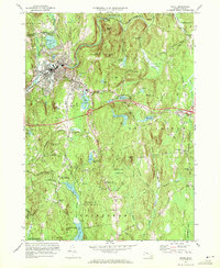 1970 Athol1972 Print · USGSAthol and Phillipston are shown during a period of steady growth along the Millers River in the early 1970s. Researchers can locate family sites and landmarks like Silver Lake Cem, Burrage Corner, and the Harvard Forest Administration Building.2 unique versions available
 - 1970 Map of Templeton, 1972 Print
 1970 Templeton1972 Print · USGSTempleton and Baldwinville are shown in the early seventies during a period of steady growth and forest preservation. Genealogists and local historians can locate several family cemeteries such as Pine Grove Cem and Greenlawn Cem, or trace the rail lines through Depot Pond.3 unique versions available
 - 1975 Map of Orange, 1981 Print
 1975 Orange1981 Print · USGSFranklin County's industrial and rural landscape is seen from above in the mid-seventies, centered on the river-front town of Orange. Researchers can trace the layout of Orange, the northern reaches of the Quabbin Reservoir, and the airfield at The Plains.
 - 1975 Map of Winsor Dam, 1981 Print
 1975 Winsor Dam1981 Print · USGSThe Quabbin Reservoir region in the mid-seventies shows a landscape defined by the balance of engineering and nature. Trace the southern shoreline from Winsor Dam down to the settlements of West Ware and Ware along the Swift River.
 - 1975 Map of Templeton, 1981 Print
 1975 Templeton1981 Print · USGSThe Worcester County landscape comes into sharp focus in the mid-seventies, showing the industrial heart of Baldwinville and Templeton. Trace the exact 1975 footprints of riverside settlements along the Otter River and the shores of Queen Lake.
 - 1975 Map of Athol, 1981 Print
 1975 Athol1981 Print · USGSThe Worcester County highlands in the mid-seventies appear in striking aerial detail, showing the contrast between riverside industry and dense forest. Genealogists and historians can trace the rural layouts of Phillipston, Phillipston Four Corners, and the settlement at Athol.
 - 1975 Map of Barre, 1981 Print
 1975 Barre1981 Print · USGSCentral Massachusetts woodlands and riverside communities are captured in this mid-seventies aerial study. Researchers can trace the development of Barre and South Barre along the Ware River and explore the remote stretches of the Burnshirt River.
 - 1975 Map of Petersham, 1981 Print
 1975 Petersham1981 Print · USGSThe Worcester County highlands appear in the mid-seventies just east of the Quabbin Reservoir. Local historians can trace old roads and rural clearings near Petersham and explore the wooded terrain around Sherman Hill.
 - 1975 Map of Quabbin Reservoir, 1981 Print
 1975 Quabbin Reservoir1981 Print · USGSIn the mid-1970s, the flooded landscapes of the Swift River Valley were managed as a vital water resource. Modern researchers can trace the shorelines near old settlements like North Prescott and Cooleyville or locate landmarks such as Mount L.
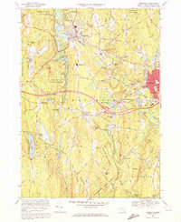
 - 1977 Map of Orange, 1978 Print
 1977 Orange1978 Print · USGSThe Millers River valley in the 1970s shows a landscape of dense state forests and small railroad hamlets. Researchers can trace family sites from Wendell Depot to South Athol, including the Village Ch and the waters of Lake Mattawa.
End of results
Showing maps 1-10 of 10
Top cities near Petersham
- Gardner historical maps
- Ludlow historical maps
- Belchertown historical maps
- Palmer historical maps
- Spencer historical maps
- Athol historical maps
See more
Top neighborhoods of Petersham
- Burrage Corner historical maps
- Nichewaug historical maps
- Bassets Corner historical maps
- Dana Commons historical maps
Frequently asked questions
- What are the different types of historical maps available for Petersham?
- What is the oldest map of Petersham?
- Where can I purchase historical maps of Petersham for my home or office?
- Where can I download high-res historical maps of Petersham?
- Are there historical topographic maps available for Petersham?
- Is there historical aerial imagery available for Petersham?
- Where are historical maps of Petersham sourced from?