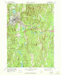
1970 Map of Athol
USGS Topo · Published 1972About this map
The industrial and residential center of Athol anchors this landscape, situated along the curve of the Millers River and the Boston and Maine Road. The town's mid-century footprint is well-defined, featuring the Athol Memorial Hospital and various schools, while cemeteries like Silver Lake Cem and Mt Pleasant Cem provide vital reference points for local genealogists. To the south and east, the character of the terrain shifts into the preserved woodlands and research sites of the Harvard Forest, which includes the Harvard Forest Administration Building and the Montessori Sch. Smaller settlements such as Phillipston and Phillipston Four Corners represent the rural communities surrounding the central hub. The area is defined by its complex water system, ranging from the Thousand Acre Reservoir to the numerous smaller ponds and brooks like Riceville Brook and Beaver Bk that feed into the larger river basins.
Find a feature on this map
74 named features on this map. Tap any name to fly to it.
Don’t see what you’re looking for? This feature index may not catch every label — zoom into the map to look around manually.
Map Details
Editions of this 1970 Athol Map
2 editions found
Other maps of this area

1887 · Warwick
USGS Topo · 1:62,500

1887 · Belchertown
USGS Topo · 1:62,500

1887 · Winchendon
USGS Topo · 1:62,500

1887 · Barre
USGS Topo · 1:62,500

1889 · Barre
USGS Topo · 1:62,500

1889 · Warwick
USGS Topo · 1:62,500

1890 · Belchertown
USGS Topo · 1:62,500

1890 · Winchendon
USGS Topo · 1:62,500

1893 · Belchertown
USGS Topo · 1:62,500

1894 · Winchendon
USGS Topo · 1:62,500