1930s Maps of Alger County, Michigan
Explore 8 historic maps of Alger County from the 1930s. These maps offer a rare glimpse into what life looked like during the 1930s — showing old roads, neighborhoods, homes, and landmarks that have changed or disappeared over time.
Whether you're researching your family's past, planning a metal detecting trip, or studying how Alger County's landscape evolved across the 1930s, these high-resolution maps are a powerful tool for exploring the history of this region.
- Focus on a specific era: All maps on this page are from the 1930s, giving you a focused view of this time period.
- See what’s changed: Compare century-old streets, trails, and buildings to today's modern landscape using overlays and satellite layers.
- Research with precision: Use these maps for genealogy, historical research, land use analysis, or educational projects.
- View, download, or print: Maps are fully viewable online in high resolution, and can be downloaded or printed for your own records.
Start exploring Alger County's history through authentic maps from the 1930s. This is your window into the past.
Alger County, MI maps
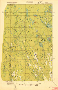
(8)- 1931 Map of Shingleton SW
 1931 Shingleton SW1931 Print · USGSThe Upper Peninsula timber and rail landscape at Shingleton comes alive in the early 1930s. Genealogists and historians can trace the intersection of the Duluth South Shore and Atlantic railroad and landmarks like Lilley Lake or Boot Lake.
 - 1931 Map of Shingleton NE
 1931 Shingleton NE1931 Print · USGSThe Alger and Schoolcraft county line in the early 1930s shows a landscape of deep marshes and glacial waters. Trace the path of the L S and Ishpeming railroad or locate the Buck Hill Fire Tower overlooking Spider Lake and the Creighton River.
 - 1931 Map of Skeels Lake NE
 1931 Skeels Lake NE1931 Print · USGSThe Upper Peninsula wilderness of the early thirties is captured here as a labyrinth of glacial waters. Researchers can trace the winding Indian River and locate remote landmarks like Hill Tower, Skeels Lake, and Straits Lake.
 - 1931 Map of Shingleton SE
 1931 Shingleton SE1931 Print · USGSSchoolcraft County in the early 1930s shows a landscape of expansive wetlands being crossed by new industrial infrastructure. Researchers can trace the path of the Duluth South Shore and Atlantic railroad and find localized points like Creighton and Hickey Creek.
 - 1931 Map of Munising SE
 1931 Munising SE1931 Print · USGSThe Michigan Upper Peninsula was a junction of major timber and freight rails in the 1930s. Genealogists and rail historians can trace the paths of the Duluth South Shore and Atlantic and old stops like Evelyn and Doty.
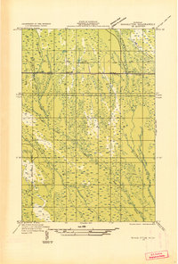
 - 1932 Map of Rock NE
 1932 Rock NE1932 Print · USGSThe timber-heavy border between Alger and Delta Counties comes to life in the early thirties. Trace the legacy of old logging camps and homesteads like Suomi Camp, Gould Homestead, and the Osier Sch along the Chicago and Northwestern rail line.
 - 1932 Map of Skandia SE
 1932 Skandia SE1932 Print · USGSIn the early 1930s, this pocket of the Upper Peninsula was a landscape of managed forests and timber-connected outposts. Genealogists can locate family sites near Dorsey Sch, the community of Sundell, and the remote Fancetts Camp along the river.
 - 1932 Map of Skandia NE
 1932 Skandia NE1932 Print · USGSThe Upper Peninsula coastline near the border of Marquette and Alger counties is captured here in the early 1930s. Trace the path of the Duluth South Shore and Atlantic railroad as it parallels the Sand River and Lake Superior shoreline.
End of results
Showing maps 1-8 of 8
Top cities of Alger County
Frequently asked questions
- What are the different types of historical maps available for Alger County?
- What is the oldest map of Alger County?
- Where can I purchase historical maps of Alger County for my home or office?
- Where can I download high-res historical maps of Alger County?
- Are there historical topographic maps available for Alger County?
- Is there historical aerial imagery available for Alger County?
- Where are historical maps of Alger County sourced from?