1980s Maps of Heath Township, Michigan
Explore 6 historic maps of Heath Township from the 1980s. These maps offer a rare glimpse into what life looked like during the 1980s — showing old roads, neighborhoods, homes, and landmarks that have changed or disappeared over time.
Whether you're researching your family's past, planning a metal detecting trip, or studying how Heath Township's landscape evolved across the 1980s, these high-resolution maps are a powerful tool for exploring the history of this region.
- Focus on a specific era: All maps on this page are from the 1980s, giving you a focused view of this time period.
- See what’s changed: Compare century-old streets, trails, and buildings to today's modern landscape using overlays and satellite layers.
- Research with precision: Use these maps for genealogy, historical research, land use analysis, or educational projects.
- View, download, or print: Maps are fully viewable online in high resolution, and can be downloaded or printed for your own records.
Start exploring Heath Township's history through authentic maps from the 1980s. This is your window into the past.
Heath Township, MI maps
(6)- 1981 Map of Hamilton East
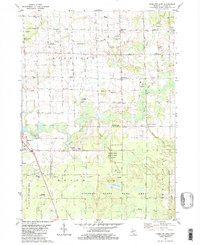 1981 Hamilton East1981 Print · USGSAllegan County in the late 1970s shows a rural landscape where farming, oil extraction, and conservation coexist. Researchers can trace family history at Oakland Cem and Diamond Springs Cem or locate old school sites like Sandy View Sch.2 unique versions available
 - 1981 Map of Millgrove
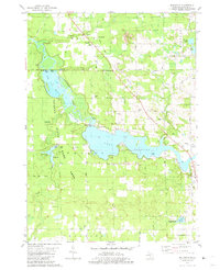 1981 Millgrove1981 Print · USGSAllegan County's riverfront and conservation lands are captured here in the early eighties as the state game area matured. Genealogists and local historians can trace family sites near Millgrove and Dunningville, or locate the Brookside Cem and Millgrove Cem.
 - 1981 Map of Fennville, 1982 Print
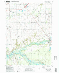
 1981 Fennville1982 Print · USGSThe Chesapeake and Ohio railroad defines this Allegan County landscape in the early eighties. Genealogists and researchers can trace local roots through Pearl Cem, Pearl, and Bravo while exploring the edges of the Ottawa Marsh.
 - 1981 Map of Hamilton West, 1982 Print
 1981 Hamilton West1982 Print · USGSAllegan County's agricultural heartland and the Kalamazoo River valley are captured here in the early eighties. Genealogists can trace family footprints through numerous rural burial grounds like Old Overisel Cem and Manlius Cem or follow the Chesapeake and Ohio rail stops.2 unique versions available
 - 1982 Map of Holland
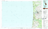 1982 Holland1982 Print · USGSThe Lake Michigan coast in the early eighties shows a refined network of Dutch-influenced settlements and lakeside retreats. Trace the rail lines of the Chesapeake and Ohio or find family landmarks near Noordeloos and New Richmond.
 - 1984 Map of Grand Rapids
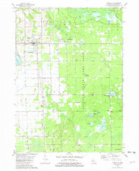
 1984 Grand Rapids1984 Print · USGSWest Michigan in the mid-eighties shows a thriving metropolitan core surrounded by expansive state recreation areas and river valleys. Genealogists and local historians can trace developments around Grand Rapids, institutional landmarks like Grand Rapids Bible College, and the quiet reaches of Jordan Lake.
End of results
Showing maps 1-6 of 6
Top cities near Heath Township
- Wyoming historical maps
- Holland historical maps
- Byron Township historical maps
- Jamestown historical maps
- Hudsonville historical maps
- Zeeland historical maps
See more
Top neighborhoods of Heath Township
Frequently asked questions
- What are the different types of historical maps available for Heath Township?
- What is the oldest map of Heath Township?
- Where can I purchase historical maps of Heath Township for my home or office?
- Where can I download high-res historical maps of Heath Township?
- Are there historical topographic maps available for Heath Township?
- Is there historical aerial imagery available for Heath Township?
- Where are historical maps of Heath Township sourced from?