1980s Maps of Alpena County, Michigan
Explore 6 historic maps of Alpena County from the 1980s. These maps offer a rare glimpse into what life looked like during the 1980s — showing old roads, neighborhoods, homes, and landmarks that have changed or disappeared over time.
Whether you're researching your family's past, planning a metal detecting trip, or studying how Alpena County's landscape evolved across the 1980s, these high-resolution maps are a powerful tool for exploring the history of this region.
- Focus on a specific era: All maps on this page are from the 1980s, giving you a focused view of this time period.
- See what’s changed: Compare century-old streets, trails, and buildings to today's modern landscape using overlays and satellite layers.
- Research with precision: Use these maps for genealogy, historical research, land use analysis, or educational projects.
- View, download, or print: Maps are fully viewable online in high resolution, and can be downloaded or printed for your own records.
Start exploring Alpena County's history through authentic maps from the 1980s. This is your window into the past.
Alpena County, MI maps
(6)- 1983 Map of Hubbard Lake, 1984 Print
 1983 Hubbard Lake1984 Print · USGSThe shorelines of Alcona and Alpena Counties come to life in this early 1980s overview of the Lake Huron coast and its deep timberlands. Researchers can trace historic rail routes like the Detroit and Mackinac or locate quiet inland hubs such as Barton City and Killmaster.
 - 1984 Map of Alpena
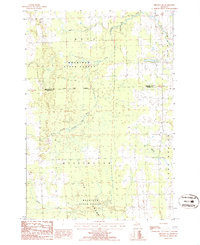
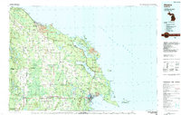 1984 Alpena1984 Print · USGSThe Lake Huron shoreline in the 1980s reveals a region defined by maritime industry, timberlands, and vast inland waters. Genealogists and historians can trace the Detroit and Mackinac Railroad past old settlements like Posen, Hagensville, and the harbor at Rockport.
 - 1986 Map of Jewett Creek
 1986 Jewett Creek1986 Print · USGSAlpena County was a landscape of dense state forests and complex river systems in the mid-eighties. Researchers can trace the path of the Old Railroad Grade through the Mackinaw State Forest or locate waters like Fletcher Pond and Long Rapids.
 - 1986 Map of Royston
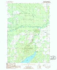
 1986 Royston1986 Print · USGSMontmorency County and the Mackinaw State Forest are shown here in the mid-1980s, revealing a landscape of dense timber and glacial lakes. Genealogists and local historians can trace the early Old Railroad Grade and find family sites near Royston or the Cem in Wellington.
 - 1986 Map of Hillman
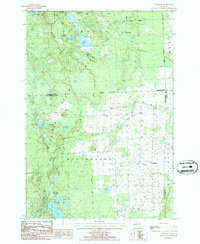
 1986 Hillman1986 Print · USGSHillman and the surrounding lake country of Montmorency County are captured here in the mid-1980s. Local researchers can trace the course of the Thunder Bay River and locate historic sites like the Cem, Gravel Pits, and Fletcher Pond.
 - 1986 Map of Hillman NE
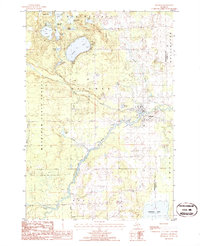
 1986 Hillman NE1986 Print · USGSNortheastern Michigan in the mid-1980s reveals a landscape of dense state timberlands and winding river systems. Local historians can trace property lines through Metz and Wellington or locate landmarks like Long Swamp and the Gravel Pit.
End of results
Showing maps 1-6 of 6
Top cities of Alpena County
Frequently asked questions
- What are the different types of historical maps available for Alpena County?
- What is the oldest map of Alpena County?
- Where can I purchase historical maps of Alpena County for my home or office?
- Where can I download high-res historical maps of Alpena County?
- Are there historical topographic maps available for Alpena County?
- Is there historical aerial imagery available for Alpena County?
- Where are historical maps of Alpena County sourced from?