1970s Maps of Antrim County, Michigan
Explore 3 historic maps of Antrim County from the 1970s. These maps offer a rare glimpse into what life looked like during the 1970s — showing old roads, neighborhoods, homes, and landmarks that have changed or disappeared over time.
Whether you're researching your family's past, planning a metal detecting trip, or studying how Antrim County's landscape evolved across the 1970s, these high-resolution maps are a powerful tool for exploring the history of this region.
- Focus on a specific era: All maps on this page are from the 1970s, giving you a focused view of this time period.
- See what’s changed: Compare century-old streets, trails, and buildings to today's modern landscape using overlays and satellite layers.
- Research with precision: Use these maps for genealogy, historical research, land use analysis, or educational projects.
- View, download, or print: Maps are fully viewable online in high resolution, and can be downloaded or printed for your own records.
Start exploring Antrim County's history through authentic maps from the 1970s. This is your window into the past.
Antrim County, MI maps
(3)- 1975 Map of Mancelona NE, 1976 Print
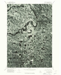 1975 Mancelona NE1976 Print · USGSNorthern Michigan’s agricultural and woodland patterns are captured in striking detail during the mid-seventies. Trace property boundaries and early building footprints across Mancelona and the nearby settlement of Antrim.
 - 1975 Map of Mancelona NW, 1976 Print
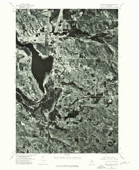 1975 Mancelona NW1976 Print · USGSAntrim County in the mid-seventies is captured in this detailed aerial perspective of the northern Chain o' Lakes region. Genealogists and local historians can trace the street layout of Bellaire and the developing shorelines of Lake Bellaire.
 - 1975 Map of Boyne City NW, 1976 Print
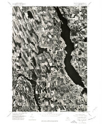 1975 Boyne City NW1976 Print · USGSNorthern Michigan during the mid-seventies comes into focus through this detailed aerial survey of the Charlevoix region. Trace the development of waterfront communities like East Jordan and Ellsworth along the shores of South Arm Lake Charlevoix.
End of results
Showing maps 1-3 of 3
Top cities of Antrim County
Frequently asked questions
- What are the different types of historical maps available for Antrim County?
- What is the oldest map of Antrim County?
- Where can I purchase historical maps of Antrim County for my home or office?
- Where can I download high-res historical maps of Antrim County?
- Are there historical topographic maps available for Antrim County?
- Is there historical aerial imagery available for Antrim County?
- Where are historical maps of Antrim County sourced from?