1960s Maps of Adams Township, Michigan
Explore 5 historic maps of Adams Township from the 1960s. These maps offer a rare glimpse into what life looked like during the 1960s — showing old roads, neighborhoods, homes, and landmarks that have changed or disappeared over time.
Whether you're researching your family's past, planning a metal detecting trip, or studying how Adams Township's landscape evolved across the 1960s, these high-resolution maps are a powerful tool for exploring the history of this region.
- Focus on a specific era: All maps on this page are from the 1960s, giving you a focused view of this time period.
- See what’s changed: Compare century-old streets, trails, and buildings to today's modern landscape using overlays and satellite layers.
- Research with precision: Use these maps for genealogy, historical research, land use analysis, or educational projects.
- View, download, or print: Maps are fully viewable online in high resolution, and can be downloaded or printed for your own records.
Start exploring Adams Township's history through authentic maps from the 1960s. This is your window into the past.
Adams Township, MI maps
(5)- 1966 Map of Midland
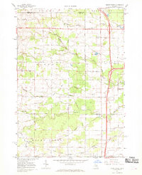
 1966 Midland1966 Print · USGSCentral Michigan in the mid-1960s shows a landscape of growing manufacturing hubs and active resource extraction. Genealogists and historians can trace the rail corridors of the Grand Trunk Western or locate family-named landmarks near Oil wells and the Muskegon River.
 - 1967 Map of Mount Forest, 1969 Print
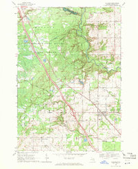
 1967 Mount Forest1969 Print · USGSBay and Arenac counties appear here in the late sixties, showing a landscape defined by drainage canals and the regional oil industry. Genealogists can trace family roots through settlements like Johnsfield and landmarks such as the Bethlehem Ch and Mount Forest.2 unique versions available
 - 1968 Map of Sterling, 1971 Print
 1968 Sterling1971 Print · USGSArenac County as it appeared in the late sixties reveals a landscape of working oil fields and small railway towns. Genealogists can trace family footprints near Alger and Sterling, locating landmarks like the Alger Cem and the Penn Central tracks.2 unique versions available
 - 1968 Map of Sterling SW, 1971 Print
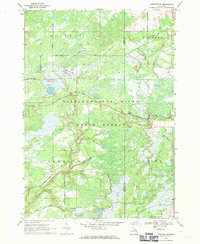 1968 Sterling SW1971 Print · USGSThe Gladwin County backcountry in the late sixties reveals a landscape of managed wetlands and forestry trails. Genealogists and outdoorsmen can locate specific landmarks like Bowmanville, the Lame Duck Truck Trail, and the curiously named Hard Luck.
 - 1969 Map of Bentley, 1972 Print
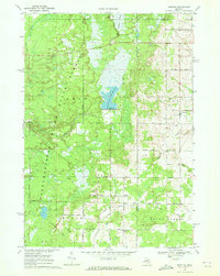 1969 Bentley1972 Print · USGSGladwin County's timberlands and river valleys are captured here in the late sixties as the local economy balanced forestry and oil. Genealogists can locate family sites near Bentley, Rhodes, and the New Rhodes Cem, or trace the Old Railroad Grade through the forest.
End of results
Showing maps 1-5 of 5
Top cities near Adams Township
- Skidway Lake historical maps
- Standish historical maps
- West Branch historical maps
- Mount Forest historical maps
- Edwards historical maps
- Pinconning historical maps
See more
Top neighborhoods of Adams Township
Frequently asked questions
- What are the different types of historical maps available for Adams Township?
- What is the oldest map of Adams Township?
- Where can I purchase historical maps of Adams Township for my home or office?
- Where can I download high-res historical maps of Adams Township?
- Are there historical topographic maps available for Adams Township?
- Is there historical aerial imagery available for Adams Township?
- Where are historical maps of Adams Township sourced from?