1970s Maps of Irving Township, Michigan
Explore 2 historic maps of Irving Township from the 1970s. These maps offer a rare glimpse into what life looked like during the 1970s — showing old roads, neighborhoods, homes, and landmarks that have changed or disappeared over time.
Whether you're researching your family's past, planning a metal detecting trip, or studying how Irving Township's landscape evolved across the 1970s, these high-resolution maps are a powerful tool for exploring the history of this region.
- Focus on a specific era: All maps on this page are from the 1970s, giving you a focused view of this time period.
- See what’s changed: Compare century-old streets, trails, and buildings to today's modern landscape using overlays and satellite layers.
- Research with precision: Use these maps for genealogy, historical research, land use analysis, or educational projects.
- View, download, or print: Maps are fully viewable online in high resolution, and can be downloaded or printed for your own records.
Start exploring Irving Township's history through authentic maps from the 1970s. This is your window into the past.
Irving Township, MI maps
(2)- 1978 Map of Freeport, 1979 Print
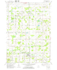 1978 Freeport1979 Print · USGSThe borderlands of Kent, Ionia, and Barry counties are captured here in the late 1970s as a landscape of rural townships and river valleys. Genealogists can trace family footprints at Fuller Cem, the crossroads of Bowne Center, and schools like Lake Sch.
 - 1978 Map of Alto, 1979 Print
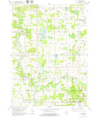 1978 Alto1979 Print · USGSSoutheast of Grand Rapids in the late seventies, this area shows a landscape of river valleys and kettle lakes. Genealogists and local historians can trace the foundations of Whitneyville, Alaska, and Alto, or locate rural landmarks like the Grange Hall and Merriman Cem.
End of results
Showing maps 1-2 of 2
Top cities near Irving Township
- Grand Rapids historical maps
- Kentwood historical maps
- Gaines Charter Township historical maps
- Cascade Charter Township historical maps
- Ada Township historical maps
- East Grand Rapids historical maps
See more
Top neighborhoods of Irving Township
Frequently asked questions
- What are the different types of historical maps available for Irving Township?
- What is the oldest map of Irving Township?
- Where can I purchase historical maps of Irving Township for my home or office?
- Where can I download high-res historical maps of Irving Township?
- Are there historical topographic maps available for Irving Township?
- Is there historical aerial imagery available for Irving Township?
- Where are historical maps of Irving Township sourced from?