Old Maps of Emerson, Whitefish Township for Metal Detecting
Plan your next treasure hunt with 12 historic maps of Emerson. Find old homesites, ghost towns, trails, and gathering spots that may be lost to time — perfect for identifying promising metal detecting locations.
- Locate forgotten sites: Uncover places like long-lost settlements, abandoned rail lines, or gathering spots.
- Plan better hunts: Use map overlays combined with LiDAR or satellite views to narrow in on historically rich areas.
- Made for detectorists: Thousands of hobbyists use these maps to discover relics, coins, and hidden history.
Use these historic maps to boost your research and find new opportunities beneath the surface of Emerson.
Emerson, Whitefish Township maps
(12)- 1951 Map of Emerson, 1955 Print
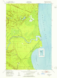 1951 Emerson1955 Print · USGSCoastal life in Chippewa County flourished along the shores of Whitefish Bay in the early 1950s. Genealogists and historians can trace the foundations of Paradise and Emerson, finding local landmarks such as the Whitefish Sch and Hiawatha Hunt Club.2 unique versions available
 - 1951 Map of Shelldrake, 1958 Print
 1951 Shelldrake1958 Print · USGSThe Upper Peninsula coastline is captured in the early fifties, showing the isolated hunting clubs and small fishing outposts of the Whitefish Point area. Genealogists and researchers can trace old settlements like Shelldrake, Emerson, and the Chippewa Hunt Post.
 - 1954 Map of Sault Sainte Marie, 1979 Print
 1954 Sault Sainte Marie1979 Print · USGSThe Eastern Upper Peninsula and Ontario borderlands are captured here at the height of the mid-century era. Family historians can trace settlements like Grand Marais and Stalwart, while mapping the strategic grounds of Kincheloe AFB.3 unique versions available
 - 1956 Map of Sault Sainte Marie, 1964 Print
 1956 Sault Sainte Marie1964 Print · USGSThe Eastern Upper Peninsula and the Canadian border meet in this mid-sixties survey of the bustling Soo Locks region. Genealogists and historians can trace the paths of the Soo Line and locate lakeside communities from Grand Marais to Shelldrake.2 unique versions available
 - 1957 Map of Sault Sainte Marie
 1957 Sault Sainte Marie1957 Print · USGSThe Upper Peninsula and Ontario border come alive in this mid-century portrait of the eastern Lake Superior shoreline and the vital St. Marys River corridor. Genealogists and historians can trace rail-era settlements from Newberry to Detour, while locating military landmarks like Kinross Air Force Base.
 - 1958 Map of Sault Sainte Marie
 1958 Sault Sainte Marie1958 Print · USGSThe eastern Upper Peninsula and the Canadian borderland appear here during the late fifties, a time of military growth and forest management. Researchers can locate vanished rail stops along the Soo Line, early sites like the Fiborn Quarry, and the sprawling Kinross Air Force Base.
 - 1985 Map of Two Hearted River
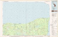 1985 Two Hearted River1985 Print · USGSThe Lake Superior coast of the Upper Peninsula is shown here during the mid-1980s, stretching from the Sucker River to Whitefish Bay. Researchers can trace remote logging grades and find small settlements such as Deer Park, Emerson, and the notable Pine Stump Junction.2 unique versions available
 - 2011 Map of Emerson, 2011 Print
 2011 Emerson2011 Print · USGSCovers Emerson, including Snug Harbor, Whitefish Township, and other nearby areas
 - 2014 Map of Emerson, 2014 Print
 2014 Emerson2014 Print · USGSCovers Emerson, including Snug Harbor, Whitefish Township, and other nearby areas
 - 2017 Map of Emerson, 2017 Print
 2017 Emerson2017 Print · USGSCovers Emerson, including Snug Harbor, Whitefish Township, and other nearby areas
 - 2019 Map of Emerson, 2019 Print
 2019 Emerson2019 Print · USGSCovers Emerson, including Snug Harbor, Whitefish Township, and other nearby areas
 - 2023 Map of Emerson, 2023 Print
 2023 Emerson2023 Print · USGSWhitefish Bay and the mouth of the Tahquamenon River define this modern look at the Chippewa County shoreline. Genealogists can locate family sites near Paradise or trace the paths of the Baptist Cem and the riverfront at Emerson.
End of results
Showing maps 1-12 of 12
Top cities near Emerson
Frequently asked questions
- What are the different types of historical maps available for Emerson?
- What is the oldest map of Emerson?
- Where can I purchase historical maps of Emerson for my home or office?
- Where can I download high-res historical maps of Emerson?
- Are there historical topographic maps available for Emerson?
- Is there historical aerial imagery available for Emerson?
- Where are historical maps of Emerson sourced from?