Old Maps of Paradise, Whitefish Township for Genealogy
Trace your family roots with 12 historic maps of Paradise. These high-res maps reveal old neighborhoods, homesites, landmarks, and streets — helping you uncover where your ancestors lived and how the area evolved over time.
- Explore historic neighborhoods: Identify where your relatives may have lived in the 1800s or 1900s.
- Compare maps over time: Trace the changes in streets, buildings, and landmarks for multi-generational research.
- Perfect for genealogy & ancestry research: Used by family historians and researchers to map out lineage and migration.
These maps are an incredible resource for exploring your personal connection to Paradise's past.
Paradise, Whitefish Township maps
(12)- 1951 Map of Shelldrake, 1955 Print
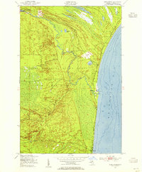 1951 Shelldrake1955 Print · USGSThe Michigan shoreline of Whitefish Bay comes alive in this early 1950s record of Chippewa County's timberlands. Researchers can trace the coastal outposts of Shelldrake and Paradise or follow the intricate windings of the Betsy River through the state forest.2 unique versions available
 - 1951 Map of Shelldrake, 1958 Print
 1951 Shelldrake1958 Print · USGSThe Upper Peninsula coastline is captured in the early fifties, showing the isolated hunting clubs and small fishing outposts of the Whitefish Point area. Genealogists and researchers can trace old settlements like Shelldrake, Emerson, and the Chippewa Hunt Post.
 - 1954 Map of Sault Sainte Marie, 1979 Print
 1954 Sault Sainte Marie1979 Print · USGSThe Eastern Upper Peninsula and Ontario borderlands are captured here at the height of the mid-century era. Family historians can trace settlements like Grand Marais and Stalwart, while mapping the strategic grounds of Kincheloe AFB.3 unique versions available
 - 1956 Map of Sault Sainte Marie, 1964 Print
 1956 Sault Sainte Marie1964 Print · USGSThe Eastern Upper Peninsula and the Canadian border meet in this mid-sixties survey of the bustling Soo Locks region. Genealogists and historians can trace the paths of the Soo Line and locate lakeside communities from Grand Marais to Shelldrake.2 unique versions available
 - 1957 Map of Sault Sainte Marie
 1957 Sault Sainte Marie1957 Print · USGSThe Upper Peninsula and Ontario border come alive in this mid-century portrait of the eastern Lake Superior shoreline and the vital St. Marys River corridor. Genealogists and historians can trace rail-era settlements from Newberry to Detour, while locating military landmarks like Kinross Air Force Base.
 - 1958 Map of Sault Sainte Marie
 1958 Sault Sainte Marie1958 Print · USGSThe eastern Upper Peninsula and the Canadian borderland appear here during the late fifties, a time of military growth and forest management. Researchers can locate vanished rail stops along the Soo Line, early sites like the Fiborn Quarry, and the sprawling Kinross Air Force Base.
 - 1985 Map of Two Hearted River
 1985 Two Hearted River1985 Print · USGSThe Lake Superior coast of the Upper Peninsula is shown here during the mid-1980s, stretching from the Sucker River to Whitefish Bay. Researchers can trace remote logging grades and find small settlements such as Deer Park, Emerson, and the notable Pine Stump Junction.2 unique versions available
 - 2011 Map of Shelldrake, 2011 Print
 2011 Shelldrake2011 Print · USGSCovers Paradise, including Whitefish Township, Chippewa County, and other nearby areas
 - 2014 Map of Shelldrake, 2014 Print
 2014 Shelldrake2014 Print · USGSCovers Paradise, including Whitefish Township, Chippewa County, and other nearby areas
 - 2017 Map of Shelldrake, 2017 Print
 2017 Shelldrake2017 Print · USGSCovers Paradise, including Whitefish Township, Chippewa County, and other nearby areas
 - 2019 Map of Shelldrake, 2019 Print
 2019 Shelldrake2019 Print · USGSCovers Paradise, including Whitefish Township, Chippewa County, and other nearby areas
 - 2023 Map of Shelldrake, 2023 Print
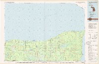
 2023 Shelldrake2023 Print · USGSWhitefish Bay and the Upper Peninsula coast are documented here in the early twenty-first century, showing the drainage of the Shelldrake River. Local historians can trace the lakeside settlements of Shelldrake and Paradise, as well as landmarks like the Paradise Cem and Andrus Lake.
End of results
Showing maps 1-12 of 12
Frequently asked questions
- What are the different types of historical maps available for Paradise?
- What is the oldest map of Paradise?
- Where can I purchase historical maps of Paradise for my home or office?
- Where can I download high-res historical maps of Paradise?
- Are there historical topographic maps available for Paradise?
- Is there historical aerial imagery available for Paradise?
- Where are historical maps of Paradise sourced from?