1940s Maps of Clinton County, Michigan
Explore 4 historic maps of Clinton County from the 1940s. These maps offer a rare glimpse into what life looked like during the 1940s — showing old roads, neighborhoods, homes, and landmarks that have changed or disappeared over time.
Whether you're researching your family's past, planning a metal detecting trip, or studying how Clinton County's landscape evolved across the 1940s, these high-resolution maps are a powerful tool for exploring the history of this region.
- Focus on a specific era: All maps on this page are from the 1940s, giving you a focused view of this time period.
- See what’s changed: Compare century-old streets, trails, and buildings to today's modern landscape using overlays and satellite layers.
- Research with precision: Use these maps for genealogy, historical research, land use analysis, or educational projects.
- View, download, or print: Maps are fully viewable online in high resolution, and can be downloaded or printed for your own records.
Start exploring Clinton County's history through authentic maps from the 1940s. This is your window into the past.
Clinton County, MI maps
(4)- 1943 Map of Perrinton
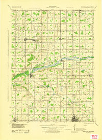 1943 Perrinton1943 Print · USGSGratiot and Clinton counties are captured here in the early 1940s, showing a landscape of fertile river valleys and established rail towns. Local historians can trace family ties through dozens of district schoolhouses like Yond Sch, industry at Stevensons Tile Mill, and the rail corridors of the Ann Arbor line.
 - 1943 Map of Elsie, 1944 Print
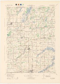 1943 Elsie1944 Print · USGSMid-century central Michigan is captured here during the wartime years, showing the intersection of four counties. Genealogists can locate dozens of country schoolhouses like Kelsey Sch and Munson Sch or trace family roots in settlements such as Elsie, Ashley, and Bannister.
 - 1944 Map of Laingsburg
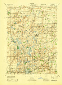 1944 Laingsburg1944 Print · USGSMid-Michigan farm country and wetlands are captured here just after the war, centered on the rail hub of Laingsburg. Researchers can trace nineteenth-century school districts like Octagon Sch and find family plots at South Ovid Cem or Stilson Cem.
 - 1945 Map of Portland, 1946 Print
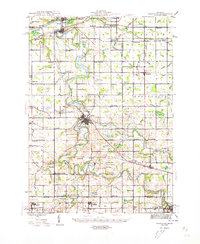 1945 Portland1946 Print · USGSCentral Michigan river valleys thrive in the 1940s as agricultural and transit hubs. Genealogists can locate dozens of family-named schoolhouses and cemeteries like Eagle Cem, while tracing the Pere Marquette rail line and Wagar Dam.3 unique versions available
End of results
Showing maps 1-4 of 4
Top cities of Clinton County
Frequently asked questions
- What are the different types of historical maps available for Clinton County?
- What is the oldest map of Clinton County?
- Where can I purchase historical maps of Clinton County for my home or office?
- Where can I download high-res historical maps of Clinton County?
- Are there historical topographic maps available for Clinton County?
- Is there historical aerial imagery available for Clinton County?
- Where are historical maps of Clinton County sourced from?