1960s Maps of Clinton County, Michigan
Explore 10 historic maps of Clinton County from the 1960s. These maps offer a rare glimpse into what life looked like during the 1960s — showing old roads, neighborhoods, homes, and landmarks that have changed or disappeared over time.
Whether you're researching your family's past, planning a metal detecting trip, or studying how Clinton County's landscape evolved across the 1960s, these high-resolution maps are a powerful tool for exploring the history of this region.
- Focus on a specific era: All maps on this page are from the 1960s, giving you a focused view of this time period.
- See what’s changed: Compare century-old streets, trails, and buildings to today's modern landscape using overlays and satellite layers.
- Research with precision: Use these maps for genealogy, historical research, land use analysis, or educational projects.
- View, download, or print: Maps are fully viewable online in high resolution, and can be downloaded or printed for your own records.
Start exploring Clinton County's history through authentic maps from the 1960s. This is your window into the past.
Clinton County, MI maps
(10)- 1961 Map of Grand Rapids
 1961 Grand Rapids1961 Print · USGSSouthern Michigan at the dawn of the 1960s reveals a region shaped by major river systems and a robust rail network. Trace mid-century industrial growth and land use from Grand Rapids to the Fort Custer Military Reservation and Gun Lake.
 - 1962 Map of Grand Rapids
 1962 Grand Rapids1962 Print · USGSMid-century Southern Michigan is mapped here at a time of massive growth, showing the expanding urban footprints of Grand Rapids and Lansing. Researchers can trace the legacy of the Grand Trunk Western RR, find historic boundaries of the Fort Custer Military Reservation, or locate sporting camps around Gun Lake.2 unique versions available
 - 1965 Map of St. Johns North, 1967 Print
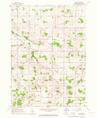
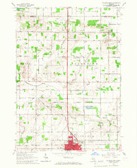 1965 St. Johns North1967 Print · USGSClinton County agriculture and the growing city of St Johns are captured here in the mid-1960s. Researchers can trace rural life through landmarks like Union Home Cem, the Sage Sch, and the Maple River State Game Area.2 unique versions available
 - 1965 Map of St. Johns South, 1967 Print
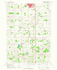 1965 St. Johns South1967 Print · USGSMid-century Clinton County comes alive in this survey of the farmlands south of St. Johns. Genealogists and local historians can trace schoolhouse locations like County Farm Sch and family landmarks near Merle Beach and Bengal Ch.3 unique versions available
 - 1965 Map of Wacousta, 1967 Print
 1965 Wacousta1967 Print · USGSMid-Michigan's agricultural and riverfront communities are captured here in the mid-1960s, showing the early growth of Grand Ledge and Wacousta. Researchers can trace old family sites near South Riley Cem, identify rural schoolhouses like Kincaid Sch, and locate regional transport hubs from Pohls Airpark to the Chesapeake and Ohio line.2 unique versions available
 - 1965 Map of Lansing North, 1967 Print
 1965 Lansing North1967 Print · USGSThe northern reaches of Lansing and the rural DeWitt area come to life in this mid-sixties survey. Researchers can trace family history at St Joseph Cemetery, locate old schoolhouses like Brown Sch, and follow the New York Central Railroad corridor.3 unique versions available
 - 1965 Map of Riley, 1967 Print
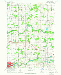
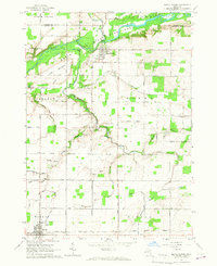
 1965 Riley1967 Print · USGSMid-Michigan farm country in the mid-sixties reveals a detailed network of agricultural drains and rural community life near Riley and Bengal Center. Genealogists can trace early landmarks such as Oak Ridge Cem, St Pauls Cem, and Harper Sch.2 unique versions available
 - 1965 Map of Maple Rapids, 1967 Print
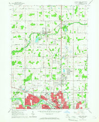
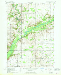
 1965 Maple Rapids1967 Print · USGSClinton County's river valley comes into sharp focus during the mid-sixties, showing the agricultural heartland between Maple Rapids and Fowler. Researchers can trace the locations of the Frink Sch, Lowe Ch, and numerous family cemeteries like Beech Cem.2 unique versions available
 - 1966 Map of Midland
 1966 Midland1966 Print · USGSCentral Michigan in the mid-1960s shows a landscape of growing manufacturing hubs and active resource extraction. Genealogists and historians can trace the rail corridors of the Grand Trunk Western or locate family-named landmarks near Oil wells and the Muskegon River.
 - 1967 Map of Hubbardston, 1968 Print
 1967 Hubbardston1968 Print · USGSThe borderlands of Ionia and Clinton counties in the late sixties reveal a landscape of river-fed agriculture and expanding state lands. Genealogists and local historians can trace the foundations of Hubbardston and Pewamo or locate rural sites like West Side Cem and the Grand Trunk rail corridor.
End of results
Showing maps 1-10 of 10
Top cities of Clinton County
Frequently asked questions
- What are the different types of historical maps available for Clinton County?
- What is the oldest map of Clinton County?
- Where can I purchase historical maps of Clinton County for my home or office?
- Where can I download high-res historical maps of Clinton County?
- Are there historical topographic maps available for Clinton County?
- Is there historical aerial imagery available for Clinton County?
- Where are historical maps of Clinton County sourced from?