1980s Maps of Kingsley, Cornell Township
Explore 2 historic maps of Kingsley from the 1980s. These maps offer a rare glimpse into what life looked like during the 1980s — showing old roads, neighborhoods, homes, and landmarks that have changed or disappeared over time.
Whether you're researching your family's past, planning a metal detecting trip, or studying how Kingsley's landscape evolved across the 1980s, these high-resolution maps are a powerful tool for exploring the history of this region.
- Focus on a specific era: All maps on this page are from the 1980s, giving you a focused view of this time period.
- See what’s changed: Compare century-old streets, trails, and buildings to today's modern landscape using overlays and satellite layers.
- Research with precision: Use these maps for genealogy, historical research, land use analysis, or educational projects.
- View, download, or print: Maps are fully viewable online in high resolution, and can be downloaded or printed for your own records.
Start exploring Kingsley's history through authentic maps from the 1980s. This is your window into the past.
Kingsley, Cornell Township maps
(2)- 1982 Map of Escanaba
 1982 Escanaba1982 Print · USGSUpper Peninsula timber and mining country come to life in this early 1980s survey of the lakefront and forest interior. Trace family roots and industrial history through settlements like Norway and Gladstone, or locate the Appleton Mine and Fernwood Cem near the rail lines.
 - 1989 Map of Woodlawn
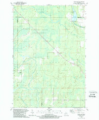 1989 Woodlawn1989 Print · USGSThe Michigan Upper Peninsula's interior is captured in the late 1980s, showcasing the intersection of the Delta, Marquette, and Menominee county lines. Researchers can locate the Cedardale Community Chapel, the Boney Falls Dam on the Escanaba River, and small settlements like Woodlawn.
End of results
Showing maps 1-2 of 2
Top cities near Kingsley
- Escanaba historical maps
- Gladstone historical maps
- Wells historical maps
- Harris historical maps
- Bark River historical maps
- Brampton historical maps
See more
Frequently asked questions
- What are the different types of historical maps available for Kingsley?
- What is the oldest map of Kingsley?
- Where can I purchase historical maps of Kingsley for my home or office?
- Where can I download high-res historical maps of Kingsley?
- Are there historical topographic maps available for Kingsley?
- Is there historical aerial imagery available for Kingsley?
- Where are historical maps of Kingsley sourced from?