1950s Maps of West Branch Township, Michigan
Explore 4 historic maps of West Branch Township from the 1950s. These maps offer a rare glimpse into what life looked like during the 1950s — showing old roads, neighborhoods, homes, and landmarks that have changed or disappeared over time.
Whether you're researching your family's past, planning a metal detecting trip, or studying how West Branch Township's landscape evolved across the 1950s, these high-resolution maps are a powerful tool for exploring the history of this region.
- Focus on a specific era: All maps on this page are from the 1950s, giving you a focused view of this time period.
- See what’s changed: Compare century-old streets, trails, and buildings to today's modern landscape using overlays and satellite layers.
- Research with precision: Use these maps for genealogy, historical research, land use analysis, or educational projects.
- View, download, or print: Maps are fully viewable online in high resolution, and can be downloaded or printed for your own records.
Start exploring West Branch Township's history through authentic maps from the 1950s. This is your window into the past.
West Branch Township, MI maps
(4)- 1955 Map of Ralph NE, 1956 Print
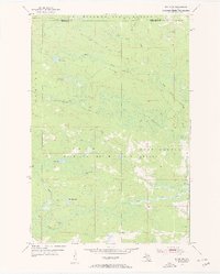 1955 Ralph NE1956 Print · USGSThe Dickinson and Marquette county line appears here in the mid-1950s, showing a remote landscape shaped by state forestry and river systems. Researchers can locate the Willit Run Landing Field and the Escanaba River Lookout Tower among the winding bends of the North Branch Ford River.3 unique versions available
 - 1955 Map of Ralph, 1957 Print
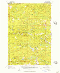 1955 Ralph1957 Print · USGSUpper Peninsula timber and rail life come into focus in the mid-1950s around the Dickinson and Marquette county line. Researchers can trace the Escanaba and Lake Superior line to local hubs like Ralph and Stafford, or locate the Ralph Cem.3 unique versions available
 - 1957 Map of Northland, 1958 Print
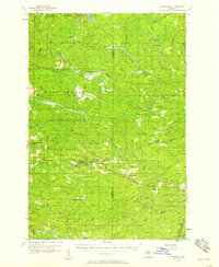 1957 Northland1958 Print · USGSThe Upper Peninsula interior shows its mid-century character during the late 1950s, where rail lines still connected remote forest outposts. Trace the old rail stops at Northland and Alfred or locate the Alfred Lookout Tower and Education Camp near the Ford River.2 unique versions available
 - 1958 Map of Marquette, 1968 Print
 1958 Marquette1968 Print · USGSThe Upper Peninsula’s central corridor is captured here in the mid-twentieth century as mining and timber industries thrived alongside new military installations. Genealogists and historians can trace the rail lines of the Soo Line Railroad through settlements like Gwinn, Turin, and Chatham.2 unique versions available
End of results
Showing maps 1-4 of 4
Top cities near West Branch Township
Top neighborhoods of West Branch Township
Frequently asked questions
- What are the different types of historical maps available for West Branch Township?
- What is the oldest map of West Branch Township?
- Where can I purchase historical maps of West Branch Township for my home or office?
- Where can I download high-res historical maps of West Branch Township?
- Are there historical topographic maps available for West Branch Township?
- Is there historical aerial imagery available for West Branch Township?
- Where are historical maps of West Branch Township sourced from?