1910s Maps of Eaton County, Michigan
Explore 6 historic maps of Eaton County from the 1910s. These maps offer a rare glimpse into what life looked like during the 1910s — showing old roads, neighborhoods, homes, and landmarks that have changed or disappeared over time.
Whether you're researching your family's past, planning a metal detecting trip, or studying how Eaton County's landscape evolved across the 1910s, these high-resolution maps are a powerful tool for exploring the history of this region.
- Focus on a specific era: All maps on this page are from the 1910s, giving you a focused view of this time period.
- See what’s changed: Compare century-old streets, trails, and buildings to today's modern landscape using overlays and satellite layers.
- Research with precision: Use these maps for genealogy, historical research, land use analysis, or educational projects.
- View, download, or print: Maps are fully viewable online in high resolution, and can be downloaded or printed for your own records.
Start exploring Eaton County's history through authentic maps from the 1910s. This is your window into the past.
Eaton County, MI maps
(6)- 1910 Map of Lansing, 1958 Print
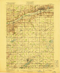
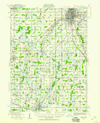 1910 Lansing1958 Print · USGSThe state capital and its surrounding agrarian townships are captured here during a period of significant growth at the start of the 1910s. Genealogists can trace hundreds of family farms and local landmarks including Dolly Varden School, Grovenberg Church, and the Pere Marquette rail lines.
 - 1912 Map of Lansing
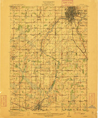 1912 Lansing1912 Print · USGSLansing and the surrounding townships are captured in 1912 as the region's rural character met the growing industrial city. Genealogists can trace family footprints through dozens of country school sites like Dolly Varden School or settlements such as Dimondale and Canada Settlement.4 unique versions available
 - 1916 Map of Ionia, 1958 Print
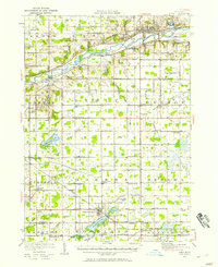 1916 Ionia1958 Print · USGSIonia and the surrounding rural townships are shown during a period of transition in the early twentieth century. Genealogists can locate numerous rural schoolhouses like Welch School and Limerick School, or trace the tracks of the Pere Marquette railroad through Saranac.2 unique versions available
 - 1918 Map of Battle Creek
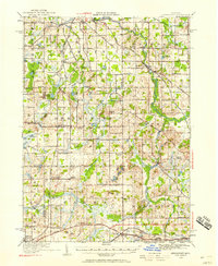
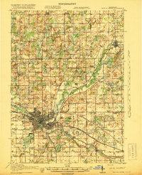 1918 Battle Creek1918 Print · USGSThe Battle Creek area thrived as a rail and industrial hub during the First World War. Genealogists can trace family footprints across rural schoolhouses like Little Brick School and settlements like Ceresco or Bellevue.4 unique versions available
 - 1918 Map of Ionia
 1918 Ionia1918 Print · USGSIonia County and northern Barry County appear here at the end of the Great War, as the river-and-rail economy peaked. Genealogists can trace family footprints across dozens of country school sites like Bushnell School and named corners such as Tremaine Corners.2 unique versions available
 - 1919 Map of Springport, 1958 Print
 1919 Springport1958 Print · USGSSouthern Michigan at the close of the Great War is a landscape of rural schoolhouses and historic turnpikes. Genealogists can locate family landmarks like Chapel Cemetery or trace the early paths of the Old Plank Road and Michigan Central Railroad.3 unique versions available
End of results
Showing maps 1-6 of 6
Top cities of Eaton County
- Charlotte historical maps
- Grand Ledge historical maps
- Eaton Rapids historical maps
- Potterville historical maps
- Olivet historical maps
Frequently asked questions
- What are the different types of historical maps available for Eaton County?
- What is the oldest map of Eaton County?
- Where can I purchase historical maps of Eaton County for my home or office?
- Where can I download high-res historical maps of Eaton County?
- Are there historical topographic maps available for Eaton County?
- Is there historical aerial imagery available for Eaton County?
- Where are historical maps of Eaton County sourced from?