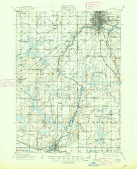
1910 Map of Lansing
USGS Topo · Published 1958About this map
The Grand River and Cedar River converge at the capital city of Lansing, which serves as the primary hub for this early twentieth-century survey. The landscape outside the city center is defined by a dense network of rural infrastructure, including a remarkable number of one-room schoolhouses such as the Dolly Varden School, New Guinea School, and Canada Settlement School. These institutions, alongside country parishes like Delta Center Church and Grovenberg Church, illustrate the established social fabric of Ingham and Eaton counties during this period.
Find a feature on this map
100 named features on this map. Tap any name to fly to it.
Don’t see what you’re looking for? This feature index may not catch every label — zoom into the map to look around manually.
Map Details
Editions of this 1910 Lansing Map
This is the sole edition of this map. No revisions or reprints were ever made.