
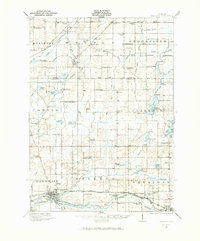
1921 Map of Marshall
USGS Topo · Published 1965About this map
Marshall and Albion serve as the southern anchors for this early 1920s survey of southern Michigan, where the Kalamazoo River and the Michigan Central Railroad form a vital transportation corridor. The landscape is heavily marked by small rural settlements and a dense network of country schools, such as the Hockinberry School and Carversville School, reflecting the township-based social structure of the era. To the north, the terrain transitions into a more hydrologically complex area around Duck Lake and Prairie Lake, where recreational and seasonal development appears at Charlotte Landing and Albion Landing. Unique institutional landmarks also punctuate the map, including the County Infirmary west of Marshall and the Starr Commonwealth near the eastern border. Notable transit features include the Electric Railroad paralleling the steam line and the distinct Olivet Station serving the community to the north.
Find a feature on this map
105 named features on this map. Tap any name to fly to it.
Don’t see what you’re looking for? This feature index may not catch every label — zoom into the map to look around manually.
Map Details
Editions of this 1921 Marshall Map
2 editions found
Other maps of this area

1910 · Lansing
USGS Topo · 1:62,500

1912 · Lansing
USGS Topo · 1:62,500

1918 · Battle Creek
USGS Topo · 1:62,500

1918 · Union City
USGS Topo · 1:62,500

1919 · Springport
USGS Topo · 1:62,500

1921 · Springport
USGS Topo · 1:62,500

1923 · Marshall
USGS Topo · 1:62,500

1943 · Battle Creek
USGS Topo · 1:62,500

1943 · Marshall
USGS Topo · 1:62,500

1947 · Bellevue
USGS Topo · 1:24,000