1940s Maps of Walton Township, Michigan
Explore 2 historic maps of Walton Township from the 1940s. These maps offer a rare glimpse into what life looked like during the 1940s — showing old roads, neighborhoods, homes, and landmarks that have changed or disappeared over time.
Whether you're researching your family's past, planning a metal detecting trip, or studying how Walton Township's landscape evolved across the 1940s, these high-resolution maps are a powerful tool for exploring the history of this region.
- Focus on a specific era: All maps on this page are from the 1940s, giving you a focused view of this time period.
- See what’s changed: Compare century-old streets, trails, and buildings to today's modern landscape using overlays and satellite layers.
- Research with precision: Use these maps for genealogy, historical research, land use analysis, or educational projects.
- View, download, or print: Maps are fully viewable online in high resolution, and can be downloaded or printed for your own records.
Start exploring Walton Township's history through authentic maps from the 1940s. This is your window into the past.
Walton Township, MI maps
(2)- 1943 Map of Marshall
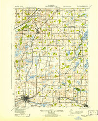 1943 Marshall1943 Print · USGSCentral Michigan during the early 1940s is defined by its busy rail corridors and small school districts. Genealogists can trace family names at locations like Hockinberry Sch, Olivet, and the Starr Commonwealth Sch.
 - 1949 Map of Charlotte
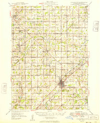 1949 Charlotte1949 Print · USGSEaton County enters the post-war era as a thriving rail hub where the Michigan Central and Grand Trunk lines meet. Genealogists and historians can trace dozens of rural schoolhouses and family cemeteries, from Shaytown to the County Farm.3 unique versions available
End of results
Showing maps 1-2 of 2
Top cities near Walton Township
- Lansing historical maps
- Albion historical maps
- Charlotte historical maps
- Marshall historical maps
- Eaton Rapids historical maps
- Potterville historical maps
See more
Top neighborhoods of Walton Township
Frequently asked questions
- What are the different types of historical maps available for Walton Township?
- What is the oldest map of Walton Township?
- Where can I purchase historical maps of Walton Township for my home or office?
- Where can I download high-res historical maps of Walton Township?
- Are there historical topographic maps available for Walton Township?
- Is there historical aerial imagery available for Walton Township?
- Where are historical maps of Walton Township sourced from?