1940s Maps of Gogebic County, Michigan
Explore 6 historic maps of Gogebic County from the 1940s. These maps offer a rare glimpse into what life looked like during the 1940s — showing old roads, neighborhoods, homes, and landmarks that have changed or disappeared over time.
Whether you're researching your family's past, planning a metal detecting trip, or studying how Gogebic County's landscape evolved across the 1940s, these high-resolution maps are a powerful tool for exploring the history of this region.
- Focus on a specific era: All maps on this page are from the 1940s, giving you a focused view of this time period.
- See what’s changed: Compare century-old streets, trails, and buildings to today's modern landscape using overlays and satellite layers.
- Research with precision: Use these maps for genealogy, historical research, land use analysis, or educational projects.
- View, download, or print: Maps are fully viewable online in high resolution, and can be downloaded or printed for your own records.
Start exploring Gogebic County's history through authentic maps from the 1940s. This is your window into the past.
Gogebic County, MI maps
(6)- 1943 Map of Little Girls Point
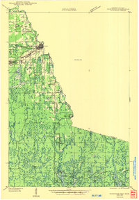
 1943 Little Girls Point1943 Print · USGSThe Lake Superior coast at the Michigan-Wisconsin border appears here in the early 1940s, showing a landscape defined by state lines and iron-range railroads. Trace the routes of the C & N W railroad near Cedar or locate the Lake View Cem in this surveyed borderland.
 - 1943 Map of Ironwood
 1943 Ironwood1943 Print · USGSThe border country between Wisconsin and Michigan comes alive in this wartime survey of the iron range and timberlands. Researchers can trace early rural life through vanished sites like the Mosinee Lumber Camp, the Chicago and Northwestern Line, and local hubs like Buskirk.2 unique versions available
 - 1943 Map of Little Girl Point
 1943 Little Girl Point1943 Print · USGSThe Lake Superior shoreline at the Wisconsin-Michigan border is shown here as it appeared in the early 1940s. Genealogists and local historians can trace the La Pointe Indian Reservation and the tracks of the Duluth South Shore and Atlantic railroad.
 - 1946 Map of Star Lake
 1946 Star Lake1946 Print · USGSVilas County was a landscape of deep woods and glacial lakes in the late thirties as the timber era gave way to early tourism. Genealogists and historians can trace the Chicago and Northwestern Line rail corridor and find early landmarks like the Monahan Fire Tower and Star Lake settlement.
 - 1946 Map of Trout Lake
 1946 Trout Lake1946 Print · USGSVilas County and the Michigan border are captured here during the late 1930s, showcasing a landscape of dense lakes and early forest management. Local historians can trace the development of Boulder Junction, the presence of a CCC Camp, and the historic State Forest Headquarters.
 - 1949 Map of Trout Lake
 1949 Trout Lake1949 Print · USGSThe Vilas County lake country is captured here during the post-war years, showcasing a dense network of waterways and early conservation sites. Researchers can locate the CCC Camp, the settlement of Boulder Junction, and the Boulder Fire Tower.
End of results
Showing maps 1-6 of 6
Top cities of Gogebic County
Frequently asked questions
- What are the different types of historical maps available for Gogebic County?
- What is the oldest map of Gogebic County?
- Where can I purchase historical maps of Gogebic County for my home or office?
- Where can I download high-res historical maps of Gogebic County?
- Are there historical topographic maps available for Gogebic County?
- Is there historical aerial imagery available for Gogebic County?
- Where are historical maps of Gogebic County sourced from?