1990s Maps of Gogebic County, Michigan
Explore 35 historic maps of Gogebic County from the 1990s. These maps offer a rare glimpse into what life looked like during the 1990s — showing old roads, neighborhoods, homes, and landmarks that have changed or disappeared over time.
Whether you're researching your family's past, planning a metal detecting trip, or studying how Gogebic County's landscape evolved across the 1990s, these high-resolution maps are a powerful tool for exploring the history of this region.
- Focus on a specific era: All maps on this page are from the 1990s, giving you a focused view of this time period.
- See what’s changed: Compare century-old streets, trails, and buildings to today's modern landscape using overlays and satellite layers.
- Research with precision: Use these maps for genealogy, historical research, land use analysis, or educational projects.
- View, download, or print: Maps are fully viewable online in high resolution, and can be downloaded or printed for your own records.
Start exploring Gogebic County's history through authentic maps from the 1990s. This is your window into the past.
Gogebic County, MI maps
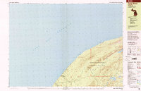
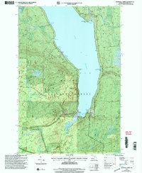
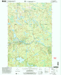
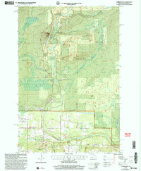
(35)- 1990 Map of Wakefield
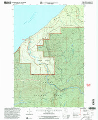
 1990 Wakefield1990 Print · USGSThe Michigan-Wisconsin borderlands are captured here in the late twentieth century, showing the transition from an industrial rail-and-timber hub to a recreation-focused landscape. Trace the Chicago & North Western RR through Marenisco or locate landmarks like Agate Falls and Wakefield.
 - 1994 Map of Carp River, 2000 Print
 1994 Carp River2000 Print · USGSThe Lake Superior shoreline and the high ridges of the Ontonagon wilderness are documented here in the mid-nineties. Researchers can locate remote industrial sites like the Old LaFayette Mine or trace the backcountry paths to Traders Falls and Mirror Lake.
 - 1999 Map of Tula, 2004 Print
 1999 Tula2004 Print · USGSThe Upper Peninsula wilderness comes into focus at the close of the twentieth century, highlighting the dense timberlands and river systems of the western region. Genealogists and researchers can trace local landmarks like Tula, Jack Spur, and the waters of the Presque Isle River.
 - 1999 Map of North Ironwood, 2004 Print
 1999 North Ironwood2004 Print · USGSThe Upper Peninsula meets the Wisconsin border at the turn of the millennium as rural communities and forests converge near the Lake Superior shore. Trace local heritage and land use through North Ironwood, the Sunset Acres Cem, and the Montreal River border.
 - 1999 Map of Lake Mitigwaki, 2004 Print
 1999 Lake Mitigwaki2004 Print · USGSUpper Peninsula wilderness near the turn of the century is defined by its vast water networks within the Ottawa National Forest. Researchers can trace remote landmarks like Bear Trap Dam, the Jumbo River, and Harding Lake.
 - 1999 Map of Tenderfoot Lake, 2004 Print
 1999 Tenderfoot Lake2004 Print · USGSThe Michigan-Wisconsin border country comes into focus in the late nineties, where the national and state forests of the Northwoods converge. Researchers can trace forest roads like Timber Wolf Road to remote landmarks including Notre Dame Ch and Fishtrap Lake.
 - 1999 Map of Merriweather, 2004 Print
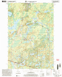
 1999 Merriweather2004 Print · USGSThe western shores of Lake Gogebic are captured here in the late 1990s as they transition into the deep woods of the Ottawa National Forest. Researchers can trace the layout of Merriweather, locate a Mobile Home Park near the water, and follow the paths of Pony Creek and Warbler Creek.
 - 1999 Map of Marshall Creek, 2004 Print
 1999 Marshall Creek2004 Print · USGSThe eastern shores of Lake Gogebic are captured here in the late nineties, documenting a landscape of state park land and national forest. Trace historical routes like Stagecoach Road and find landmarks such as St Thomas Church Camp and Alligator Eye.
 - 1999 Map of Stateline Lake, 2004 Print
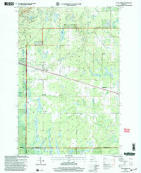
 1999 Stateline Lake2004 Print · USGSThe Michigan-Wisconsin borderlands appear here in the late nineties as a dense network of forest roads and glacial lakes. Local researchers can trace the footprint of Camp Ojibway and early lakefront developments like Bobcat Lake Beach.
 - 1999 Map of Thomaston, 2004 Print
 1999 Thomaston2004 Print · USGSThe Ottawa National Forest in the late nineties is revealed here through its timber and recreational landscapes. Trace local history at Thomaston, Connorville, and the Manley Siding rail point, or explore landmarks like Gabbro Falls and the Indianhead Mountain Ski Area.
 - 1999 Map of Thayer, 2004 Print
 1999 Thayer2004 Print · USGSThe Ottawa National Forest at the turn of the millennium shows a landscape defined by the Chicago and North Western line. Trace the rail corridor through Thayer and Gogebic Station or locate remote water features like Kakabika Falls.
 - 1999 Map of Tiebel Creek, 2004 Print
 1999 Tiebel Creek2004 Print · USGSThe Lake Superior shoreline and the deep woods of the Upper Peninsula are captured here in the late nineties. Explore the numerous cascades of the Presque Isle River, including Manabezho Falls and Nokomis Falls, within the Porcupine Mountains State Park.
 - 1999 Map of Imp Lake, 2004 Print
 1999 Imp Lake2004 Print · USGSThe Michigan-Wisconsin borderlands appear here in the late twentieth century, centered on the lakes and forests of Gogebic County. Researchers can trace the layout of the Katakitekon Indian Village, locate the Katakitekon Indian Village Cem, and find remote points on Lac Vieux Desert like Misery Bay.
 - 1999 Map of Black River Harbor, 2004 Print
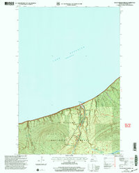 1999 Black River Harbor2004 Print · USGSLake Superior's southern shore meets the dense woods of Gogebic County in the late nineties as the Forest Service managed this river corridor. Trace the sequence of falls along the Black River, from Potawatomi Falls to Rainbow Falls, and locate the Black River Harbor Ranger Station.
 - 1999 Map of Ewen, 2004 Print
 1999 Ewen2004 Print · USGSThe community of Ewen and the Ontonagon River valley are shown at the end of the century during a period of sustained forest management. Researchers can trace local lineage at the Cem and explore historic routes like Choate Road or find the old Roadside Park.
 - 1999 Map of Fuller, 2004 Print
 1999 Fuller2004 Print · USGSThe Upper Peninsula wilderness of Gogebic County is captured here in the late twentieth century, showing a landscape defined by forest management and remote water systems. Genealogists and researchers can locate Fuller and the Interior Cem, or trace landmarks like Mex-i-min-e Falls and Burned Dam.
 - 1999 Map of Golden Lake, 2004 Print
 1999 Golden Lake2004 Print · USGSThe Upper Peninsula’s lake country is captured in the late nineties, showing a landscape of dense timber and quiet waterways. Researchers can trace the development of Elmwood and the Golden Lake Recreation Area or locate remote camps near James Lake.
 - 1999 Map of Choate, 2004 Print
 1999 Choate2004 Print · USGSUpper Peninsula timberlands and river systems are documented here at the close of the twentieth century. Genealogists and outdoorsmen can trace remote waterways like the Cisco Branch Ontonagon River, locate Wolverine Falls, and find the settlement of Choate.
 - 1999 Map of Matchwood, 2004 Print
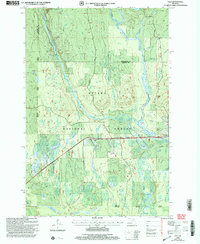
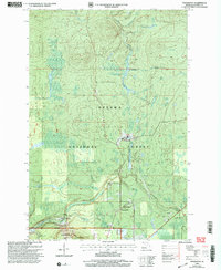
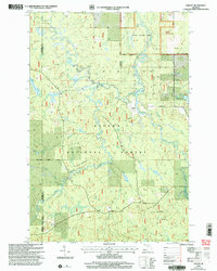
 1999 Matchwood2004 Print · USGSOntonagon County near the turn of the millennium shows a landscape defined by forest management and small rural outposts. Researchers can trace the local infrastructure around Matchwood and Topaz, from the remote Airstrip to the winding course of Tenmile Creek.2 unique versions available
 - 1999 Map of Bergland, 2004 Print
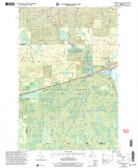
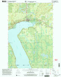 1999 Bergland2004 Print · USGSUpper Peninsula life at the edge of the wilderness is centered around the town of Bergland and the northern shores of Lake Gogebic in the late nineties. Genealogists and local historians can locate Forest Lawn Cem and trace the original infrastructure of the Bergland Dam Gaging Station.
 - 1999 Map of Copper Peak, 2004 Print
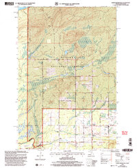
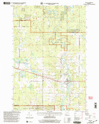
 1999 Copper Peak2004 Print · USGSGogebic County at the close of the millennium showcases a landscape where the rugged Ottawa National Forest meets modern recreation. Researchers can trace the development of the Big Powderhorn Ski Area, the Gogebic County Airport, and the settlement of North Bessemer.
 - 1999 Map of Nighthawk Creek, 2004 Print
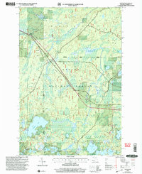
 1999 Nighthawk Creek2004 Print · USGSThe northern edge of the Upper Peninsula meets the Great Lakes in the late nineties, showing a nearly pristine stretch of coastal wilderness. Researchers can trace the narrow drainage of Nighthawk Creek and the path of the Bessemer Ranger District Road through the Ottawa National Forest.
 - 1999 Map of Gogebic, 2004 Print
 1999 Gogebic2004 Print · USGSThe Northwoods of Upper Michigan are shown here at the turn of the millennium, revealing a dense lacustrine landscape within the Ottawa National Forest. Local historians can trace the paths of Stagecoach Road and Marenisco Road past remote sites like Pomeroy Lake and the Gravel Pit near Gogebic.
 - 1999 Map of Wakefield, 2004 Print
 1999 Wakefield2004 Print · USGSThe Upper Peninsula mining and forest lands of Gogebic County are shown here at the turn of the millennium. Researchers can trace the industrial footprint of the Sunday Lake Mine and locate civic landmarks like City Hall and Lakeside Cem.
 - 1999 Map of Presque Isle, 2004 Print
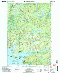
 1999 Presque Isle2004 Print · USGSThe Vilas County lakeland at the turn of the century shows a landscape integrated into two major forests. Researchers can trace the development of recreation and conservation near Presque Isle, locating landmarks like the Dairymens Country Club, Wildcat Lookout, and Stateline Lookout.
Showing maps 1-25 of 35
Top cities of Gogebic County
Frequently asked questions
- What are the different types of historical maps available for Gogebic County?
- What is the oldest map of Gogebic County?
- Where can I purchase historical maps of Gogebic County for my home or office?
- Where can I download high-res historical maps of Gogebic County?
- Are there historical topographic maps available for Gogebic County?
- Is there historical aerial imagery available for Gogebic County?
- Where are historical maps of Gogebic County sourced from?