1990s Maps of Watersmeet Township, Michigan
Explore 13 historic maps of Watersmeet Township from the 1990s. These maps offer a rare glimpse into what life looked like during the 1990s — showing old roads, neighborhoods, homes, and landmarks that have changed or disappeared over time.
Whether you're researching your family's past, planning a metal detecting trip, or studying how Watersmeet Township's landscape evolved across the 1990s, these high-resolution maps are a powerful tool for exploring the history of this region.
- Focus on a specific era: All maps on this page are from the 1990s, giving you a focused view of this time period.
- See what’s changed: Compare century-old streets, trails, and buildings to today's modern landscape using overlays and satellite layers.
- Research with precision: Use these maps for genealogy, historical research, land use analysis, or educational projects.
- View, download, or print: Maps are fully viewable online in high resolution, and can be downloaded or printed for your own records.
Start exploring Watersmeet Township's history through authentic maps from the 1990s. This is your window into the past.
Watersmeet Township, MI maps
(13)- 1990 Map of Wakefield
 1990 Wakefield1990 Print · USGSThe Michigan-Wisconsin borderlands are captured here in the late twentieth century, showing the transition from an industrial rail-and-timber hub to a recreation-focused landscape. Trace the Chicago & North Western RR through Marenisco or locate landmarks like Agate Falls and Wakefield.
 - 1999 Map of Lake Mitigwaki, 2004 Print
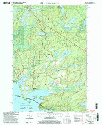
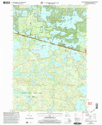
 1999 Lake Mitigwaki2004 Print · USGSUpper Peninsula wilderness near the turn of the century is defined by its vast water networks within the Ottawa National Forest. Researchers can trace remote landmarks like Bear Trap Dam, the Jumbo River, and Harding Lake.
 - 1999 Map of Thayer, 2004 Print
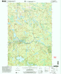
 1999 Thayer2004 Print · USGSThe Ottawa National Forest at the turn of the millennium shows a landscape defined by the Chicago and North Western line. Trace the rail corridor through Thayer and Gogebic Station or locate remote water features like Kakabika Falls.
 - 1999 Map of Imp Lake, 2004 Print
 1999 Imp Lake2004 Print · USGSThe Michigan-Wisconsin borderlands appear here in the late twentieth century, centered on the lakes and forests of Gogebic County. Researchers can trace the layout of the Katakitekon Indian Village, locate the Katakitekon Indian Village Cem, and find remote points on Lac Vieux Desert like Misery Bay.
 - 1999 Map of Fuller, 2004 Print
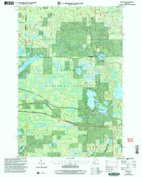
 1999 Fuller2004 Print · USGSThe Upper Peninsula wilderness of Gogebic County is captured here in the late twentieth century, showing a landscape defined by forest management and remote water systems. Genealogists and researchers can locate Fuller and the Interior Cem, or trace landmarks like Mex-i-min-e Falls and Burned Dam.
 - 1999 Map of Golden Lake, 2004 Print
 1999 Golden Lake2004 Print · USGSThe Upper Peninsula’s lake country is captured in the late nineties, showing a landscape of dense timber and quiet waterways. Researchers can trace the development of Elmwood and the Golden Lake Recreation Area or locate remote camps near James Lake.
 - 1999 Map of Smoky Lake, 2004 Print
 1999 Smoky Lake2004 Print · USGSThe Michigan-Wisconsin borderlands appear here in the late twentieth century as a heavily forested landscape of glacial lakes. Local historians and sportsmen can trace access points to Big Sand Lake, the Phelps Municipal Landing Strip, and secluded waters like Kaine Lake.
 - 1999 Map of Phelps, 2004 Print
 1999 Phelps2004 Print · USGSNorthern Vilas County is shown here just before the millennium, where the lake-studded landscape meets the Michigan border. Trace the shorelines of North Twin Lake and Long Lake, or locate landmarks like Military Hill and the town of Phelps.
 - 1999 Map of Land O'Lakes, 2005 Print
 1999 Land O'Lakes2005 Print · USGSThe Wisconsin-Michigan border country comes into sharp focus during the late 1990s, revealing a landscape defined by Northwoods lakes and federal forest lands. Researchers can trace local landmarks like Land O' Lakes, the Sylvania Wilderness, and the Land O' Lakes Airport.
 - 1999 Map of Black Oak Lake, 2005 Print
 1999 Black Oak Lake2005 Print · USGSVilas County and the Michigan border country are shown here in the late 1990s as a haven of glacial lakes and protected forests. Researchers can pinpoint family sites near Oak Hill Cem or trace the early campus of the Conserve Sch.
 - 1999 Map of Beaton, 2005 Print
 1999 Beaton2005 Print · USGSThe Upper Peninsula forest lands near Beaton are shown here in the late nineties as the region balanced wilderness preservation with forest management. Genealogists and researchers can trace the roads around Beaton Lake or locate the LANDING STRIP and Sylvania Wilderness boundary.
 - 1999 Map of Watersmeet, 2005 Print
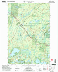
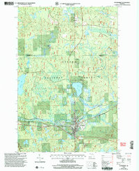 1999 Watersmeet2005 Print · USGSUpper Peninsula timberlands and river systems are documented here at the end of the century. Genealogists and local historians can trace the development of Watersmeet and Bonifas while locating family sites near the Cem and Ajibikoka Falls.
 - 1999 Map of Thousand Island Lake, 2005 Print
 1999 Thousand Island Lake2005 Print · USGSThe Michigan and Wisconsin borderlands are captured here at the close of the century, showing the dense lake country of the Northwoods. Genealogists and historians can trace the remote roads and landings of the Ottawa National Forest, from Indian Point on Thousand Island Lake to the secluded reaches of the Sylvania Wilderness.
End of results
Showing maps 1-13 of 13
Top cities near Watersmeet Township
Top neighborhoods of Watersmeet Township
- Beaton historical maps
- Thayer historical maps
- Fuller historical maps
- Tamarack historical maps
- Stickley historical maps
- Katakitckon Indian Village historical maps
See more
Frequently asked questions
- What are the different types of historical maps available for Watersmeet Township?
- What is the oldest map of Watersmeet Township?
- Where can I purchase historical maps of Watersmeet Township for my home or office?
- Where can I download high-res historical maps of Watersmeet Township?
- Are there historical topographic maps available for Watersmeet Township?
- Is there historical aerial imagery available for Watersmeet Township?
- Where are historical maps of Watersmeet Township sourced from?