1940s Maps of Houghton, Michigan
Explore 6 historic maps of Houghton from the 1940s. These maps offer a rare glimpse into what life looked like during the 1940s — showing old roads, neighborhoods, homes, and landmarks that have changed or disappeared over time.
Whether you're researching your family's past, planning a metal detecting trip, or studying how Houghton's landscape evolved across the 1940s, these high-resolution maps are a powerful tool for exploring the history of this region.
- Focus on a specific era: All maps on this page are from the 1940s, giving you a focused view of this time period.
- See what’s changed: Compare century-old streets, trails, and buildings to today's modern landscape using overlays and satellite layers.
- Research with precision: Use these maps for genealogy, historical research, land use analysis, or educational projects.
- View, download, or print: Maps are fully viewable online in high resolution, and can be downloaded or printed for your own records.
Start exploring Houghton's history through authentic maps from the 1940s. This is your window into the past.
Houghton, MI maps
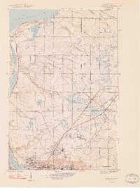
(6)- 1946 Map of Hancock, 1965 Print
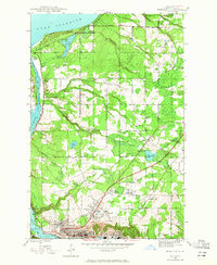 1946 Hancock1965 Print · USGSHancock and the surrounding copper country appear here during the post-war industrial era. Genealogists and historians can trace the foundations of Suomi College, the deep excavations of the Franklin Mine, and the vanished stops of the Copper Range railroad.5 unique versions available
 - 1946 Map of Chassell, 1966 Print
 1946 Chassell1966 Print · USGSThe Copper Country of Michigan's Upper Peninsula comes to life in this mid-century survey of the port towns and mining districts along the Keweenaw. Genealogists and industrial historians can trace the Isle Royale Mine, the campus of the Michigan College of Mining and Technology, and small-town roots in Dodgeville or Atlantic Mine.2 unique versions available
 - 1946 Map of South Range, 1966 Print
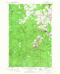 1946 South Range1966 Print · USGSHoughton County’s copper mining district is captured here just after the war, showing the tight-knit company towns and rail lines of the Keweenaw. Genealogists and industrial historians can trace the footprint of Painesdale, the Atlantic Mine, and the Copper Range railroad.3 unique versions available
 - 1948 Map of South Range
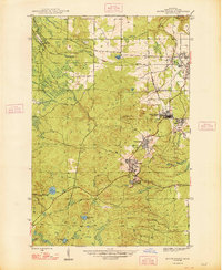 1948 South Range1948 Print · USGSThe Michigan Copper Country is captured here during the late 1940s, highlighting the industrial corridor from Atlantic Mine south through Painesdale. Genealogists and historians can trace the precise layouts of mining locations such as Baltic and Trimountain, as well as the COPPER RANGE rail network.2 unique versions available
 - 1948 Map of Hancock
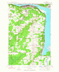
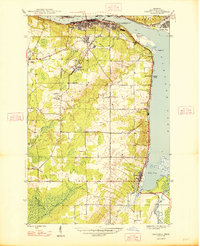
 1948 Hancock1948 Print · USGSThe Copper Country of Michigan's Upper Peninsula comes alive in the late 1940s, showing the intersection of heavy mining industry and Great Lakes maritime life. Genealogists can trace family roots through Hancock, Pewabic, and Paavola, or locate ancestors at WAASA CEM.2 unique versions available
 - 1948 Map of Chassell
 1948 Chassell1948 Print · USGSThe copper mining heart of the Keweenaw Peninsula is shown here during its mid-century industrial peak. Researchers can trace the rail lines of the Copper Range and locate old mining operations like the Isle Royale Mine and Old Superior Mine.2 unique versions available
End of results
Showing maps 1-6 of 6
Top cities near Houghton
- Hancock historical maps
- Laurium historical maps
- Osceola historical maps
- Chassell historical maps
- Allouez historical maps
- Lake Linden historical maps
See more
Top neighborhoods of Houghton
Frequently asked questions
- What are the different types of historical maps available for Houghton?
- What is the oldest map of Houghton?
- Where can I purchase historical maps of Houghton for my home or office?
- Where can I download high-res historical maps of Houghton?
- Are there historical topographic maps available for Houghton?
- Is there historical aerial imagery available for Houghton?
- Where are historical maps of Houghton sourced from?