1980s Maps of Stanton Township, Michigan
Explore 3 historic maps of Stanton Township from the 1980s. These maps offer a rare glimpse into what life looked like during the 1980s — showing old roads, neighborhoods, homes, and landmarks that have changed or disappeared over time.
Whether you're researching your family's past, planning a metal detecting trip, or studying how Stanton Township's landscape evolved across the 1980s, these high-resolution maps are a powerful tool for exploring the history of this region.
- Focus on a specific era: All maps on this page are from the 1980s, giving you a focused view of this time period.
- See what’s changed: Compare century-old streets, trails, and buildings to today's modern landscape using overlays and satellite layers.
- Research with precision: Use these maps for genealogy, historical research, land use analysis, or educational projects.
- View, download, or print: Maps are fully viewable online in high resolution, and can be downloaded or printed for your own records.
Start exploring Stanton Township's history through authentic maps from the 1980s. This is your window into the past.
Stanton Township, MI maps
(3)- 1982 Map of Donken, 1983 Print
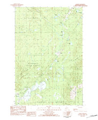 1982 Donken1983 Print · USGSThe Keweenaw Peninsula forestlands and glacial lakes are shown here in the early eighties as a quiet region of timber and recreation. Local historians can trace the small settlements of Donken and Toivola or the boundaries of Twin Lakes State Park.
 - 1982 Map of Winona North, 1983 Print
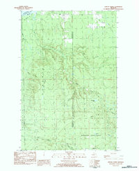 1982 Winona North1983 Print · USGSThe Upper Peninsula shoreline and the timberlands of Stanton are captured here in the early 1980s. Local researchers can trace the roads near Winona, locate the Townhall at Misery Bay, and find remote outposts like Camp 18 and Ahola.
 - 1985 Map of Hancock
 1985 Hancock1985 Print · USGSThe Keweenaw Peninsula in the mid-1980s reveals a landscape shaped by copper and the Great Lakes. You can trace the industrial legacy of the region through the Quincy Mine, the Old RR Grade, and old cemeteries like Forest Hill Cem.3 unique versions available
End of results
Showing maps 1-3 of 3
Top cities near Stanton Township
Top neighborhoods of Stanton Township
- Schmidt Corner historical maps
- Freda historical maps
- Redridge historical maps
- Salmon Trout historical maps
- Liminga historical maps
- Oskar historical maps
See more
Frequently asked questions
- What are the different types of historical maps available for Stanton Township?
- What is the oldest map of Stanton Township?
- Where can I purchase historical maps of Stanton Township for my home or office?
- Where can I download high-res historical maps of Stanton Township?
- Are there historical topographic maps available for Stanton Township?
- Is there historical aerial imagery available for Stanton Township?
- Where are historical maps of Stanton Township sourced from?