1940s Maps of Ionia County, Michigan
Explore 3 historic maps of Ionia County from the 1940s. These maps offer a rare glimpse into what life looked like during the 1940s — showing old roads, neighborhoods, homes, and landmarks that have changed or disappeared over time.
Whether you're researching your family's past, planning a metal detecting trip, or studying how Ionia County's landscape evolved across the 1940s, these high-resolution maps are a powerful tool for exploring the history of this region.
- Focus on a specific era: All maps on this page are from the 1940s, giving you a focused view of this time period.
- See what’s changed: Compare century-old streets, trails, and buildings to today's modern landscape using overlays and satellite layers.
- Research with precision: Use these maps for genealogy, historical research, land use analysis, or educational projects.
- View, download, or print: Maps are fully viewable online in high resolution, and can be downloaded or printed for your own records.
Start exploring Ionia County's history through authentic maps from the 1940s. This is your window into the past.
Ionia County, MI maps
(3)- 1943 Map of Ionia, 1944 Print
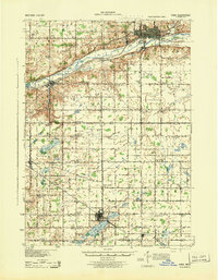 1943 Ionia1944 Print · USGSCentral Michigan’s rural landscape during the wartime era shows a dense network of country schoolhouses and river-valley institutions. Genealogists and local historians can trace family-named landmarks like Henderleider Sch and Saranac along the Pere Marquette rail line.
 - 1943 Map of Lowell, 1944 Print
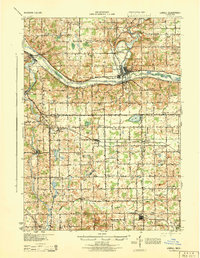 1943 Lowell1944 Print · USGSCentral Michigan river valleys and rural townships are captured here during the early 1940s. Genealogists can locate numerous namesake schoolhouses like Yerkes Sch and Cooke Sch, or trace the rail lines through Alto and Fallassburg.
 - 1945 Map of Portland, 1946 Print
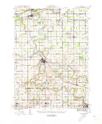 1945 Portland1946 Print · USGSCentral Michigan river valleys thrive in the 1940s as agricultural and transit hubs. Genealogists can locate dozens of family-named schoolhouses and cemeteries like Eagle Cem, while tracing the Pere Marquette rail line and Wagar Dam.3 unique versions available
End of results
Showing maps 1-3 of 3
Top cities of Ionia County
Frequently asked questions
- What are the different types of historical maps available for Ionia County?
- What is the oldest map of Ionia County?
- Where can I purchase historical maps of Ionia County for my home or office?
- Where can I download high-res historical maps of Ionia County?
- Are there historical topographic maps available for Ionia County?
- Is there historical aerial imagery available for Ionia County?
- Where are historical maps of Ionia County sourced from?