1970s Maps of Plainfield Township, Michigan
Explore 2 historic maps of Plainfield Township from the 1970s. These maps offer a rare glimpse into what life looked like during the 1970s — showing old roads, neighborhoods, homes, and landmarks that have changed or disappeared over time.
Whether you're researching your family's past, planning a metal detecting trip, or studying how Plainfield Township's landscape evolved across the 1970s, these high-resolution maps are a powerful tool for exploring the history of this region.
- Focus on a specific era: All maps on this page are from the 1970s, giving you a focused view of this time period.
- See what’s changed: Compare century-old streets, trails, and buildings to today's modern landscape using overlays and satellite layers.
- Research with precision: Use these maps for genealogy, historical research, land use analysis, or educational projects.
- View, download, or print: Maps are fully viewable online in high resolution, and can be downloaded or printed for your own records.
Start exploring Plainfield Township's history through authentic maps from the 1970s. This is your window into the past.
Plainfield Township, MI maps
(2)- 1972 Map of Goodar, 1975 Print
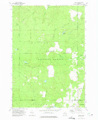 1972 Goodar1975 Print · USGSThe northern Michigan woods of the early seventies are captured here during a period of steady forestry and recreation. Researchers can trace legacy timber routes like the Old RR Grade and locate features such as Goodar, Hughes Lake, and a Flowing Well.3 unique versions available
 - 1972 Map of Alcona Dam Pond, 1975 Print
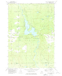 1972 Alcona Dam Pond1975 Print · USGSThe Au Sable River and the extensive Alcona Dam Pond define this Alcona County landscape in the early 1970s. Trace local family history at Curtisville and the Curtisville Cem, or locate the Alcona Dam and its associated powerplant.2 unique versions available
End of results
Showing maps 1-2 of 2
Top cities near Plainfield Township
Top neighborhoods of Plainfield Township
Frequently asked questions
- What are the different types of historical maps available for Plainfield Township?
- What is the oldest map of Plainfield Township?
- Where can I purchase historical maps of Plainfield Township for my home or office?
- Where can I download high-res historical maps of Plainfield Township?
- Are there historical topographic maps available for Plainfield Township?
- Is there historical aerial imagery available for Plainfield Township?
- Where are historical maps of Plainfield Township sourced from?