1950s Maps of Iron County, Michigan
Explore 16 historic maps of Iron County from the 1950s. These maps offer a rare glimpse into what life looked like during the 1950s — showing old roads, neighborhoods, homes, and landmarks that have changed or disappeared over time.
Whether you're researching your family's past, planning a metal detecting trip, or studying how Iron County's landscape evolved across the 1950s, these high-resolution maps are a powerful tool for exploring the history of this region.
- Focus on a specific era: All maps on this page are from the 1950s, giving you a focused view of this time period.
- See what’s changed: Compare century-old streets, trails, and buildings to today's modern landscape using overlays and satellite layers.
- Research with precision: Use these maps for genealogy, historical research, land use analysis, or educational projects.
- View, download, or print: Maps are fully viewable online in high resolution, and can be downloaded or printed for your own records.
Start exploring Iron County's history through authentic maps from the 1950s. This is your window into the past.
Iron County, MI maps
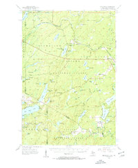
(16)- 1954 Map of Kenton, 1956 Print
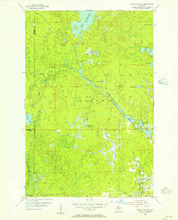
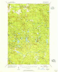 1954 Kenton1956 Print · USGSThe Upper Peninsula rail corridors and timberlands are well-defined in the mid-1950s, centering on the crossing of the Duluth South Shore and Atlantic. Researchers can locate historic sites like the Kenton Cemetery, Holmes Dam, and the old Lookout Tower.3 unique versions available
 - 1954 Map of Perch Lake, 1956 Print
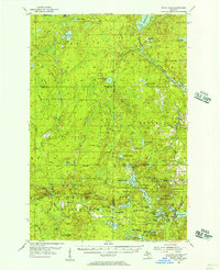
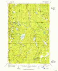 1954 Perch Lake1956 Print · USGSUpper Peninsula timberlands and glacial lakes are shown here during the mid-fifties at the meeting of Houghton, Baraga, and Iron Counties. Trace the Milwaukee Road rail line through Tunis or locate the Lookout Tower and Snake Rapids.3 unique versions available
 - 1954 Map of Iron Mountain, 1964 Print
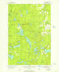
 1954 Iron Mountain1964 Print · USGSUpper Michigan and Northeastern Wisconsin are shown in detail during the mid-fifties, when the logging and mining economies still moved by rail. Trace the rail lines of the Soo Line to remote stops like Koepenick Station or explore the Iron Range near Iron Mountain.2 unique versions available
 - 1955 Map of Witch Lake, 1956 Print
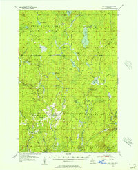
 1955 Witch Lake1956 Print · USGSThe Upper Peninsula wilderness of the mid-fifties is captured here along the Iron and Marquette county line. Genealogists and collectors can trace the rail sidings at Witbeck and explore dozens of named waters like Fence Lake and Sundog Lake.3 unique versions available
 - 1955 Map of Ned Lake, 1956 Print
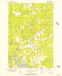
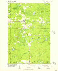
 1955 Ned Lake1956 Print · USGSIron County's timberlands and glacial lakes are captured in the mid-fifties, showing a landscape of state forests and rail history. Trace local landmarks like the Triangle Ranch, the Amasa Landing Field, and the Old Railroad Grade.3 unique versions available
 - 1955 Map of Witch Lake NE, 1956 Print
 1955 Witch Lake NE1956 Print · USGSUpper Peninsula wilderness at the edge of Marquette County is documented here during the mid-fifties. Researchers can trace the winding Michigamme River and find named landmarks like Trout Falls, Dashwa Lake, and the Iron Range State Forest.2 unique versions available
 - 1955 Map of Witch Lake, 1957 Print
 1955 Witch Lake1957 Print · USGSThe Upper Peninsula timber and rail landscape is captured here in the mid-fifties, showing the intersection of Marquette, Baraga, and Iron counties. You can trace the path of the Chicago and North Western railroad past Witbeck or locate the Lookout Tower and Nilsson Dam deep in the state forests.3 unique versions available
 - 1955 Map of Randville, 1957 Print
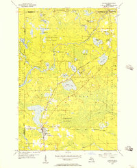
 1955 Randville1957 Print · USGSThe Michigan-Wisconsin borderlands come alive in the mid-1950s as the rail-and-timber economy defines the landscape. Trace the Milwaukee Road through settlements like Randville and Merriman or locate early lakeside landmarks near Badwater Lake.3 unique versions available
 - 1955 Map of Channing, 1957 Print
 1955 Channing1957 Print · USGSUpper Peninsula timber and rail country come alive in the mid-1950s at the junction of two major rail lines. Genealogists can locate the Channing Cem and trace small settlements like Floodwood and Golden along the Michigamme River.2 unique versions available
 - 1956 Map of Beechwood, 1957 Print
 1956 Beechwood1957 Print · USGSUpper Peninsula timberlands meet the Wisconsin Northwoods in the 1950s, a landscape defined by rail-line outposts and forestry stations. Researchers can find old rural school sites like Elvoy Sch, the Beechwood Ch, and remote rail stops at Elmwood and Basswood.4 unique versions available
 - 1956 Map of Sagola, 1957 Print
 1956 Sagola1957 Print · USGSThe settlement of Sagola stands as a mid-century logging and rail crossroads in the Upper Peninsula. Trace the route of the Chicago Milwaukee St Paul and Pacific railroad through the Sturgeon River State Forest past Tobey Lake and the local Lookout Tower.
 - 1956 Map of Kiernan, 1957 Print
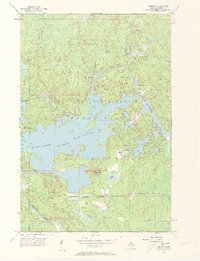 1956 Kiernan1957 Print · USGSThe Iron Range State Forest area in the mid-1950s is defined by the massive Michigamme Reservoir and its surrounding timberlands. Researchers can trace the path of the Chicago Milwaukee St Paul and Pacific railroad through Kiernan and locate early sites like McMillan Camp and Way Dam.4 unique versions available
 - 1956 Map of Sagola, 1957 Print
 1956 Sagola1957 Print · USGSUpper Peninsula timber and rail history converge in the mid-fifties at the junction of the Chicago and North Western Railway. Trace the footprints of logging and mining settlements at Channing, Mansfield Location, and the McMillan Camp.
 - 1956 Map of Lake Mary, 1957 Print
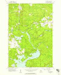 1956 Lake Mary1957 Print · USGSIron County's timber and river lands are captured here in the mid-fifties, just as the region's industrial footprint was evolving. Genealogists and historians can trace the Railroad Grade near Mansfield and locate the historic Mansfield Location.3 unique versions available
 - 1958 Map of Iron River, 1968 Print
 1958 Iron River1968 Print · USGSThe Upper Peninsula in the late fifties is captured here as a landscape of timber, iron, and rail. Genealogists and historians can trace rail stops like Mass Station or explore the coastlines of Lake Gogebic and Keweenaw Bay.3 unique versions available
 - 1959 Map of Iron Mountain
 1959 Iron Mountain1959 Print · USGSThe northwoods of Wisconsin and the Michigan border are captured here in the mid-fifties, showing a landscape defined by timber, water, and rail. Researchers can trace historic junctions like Hiles Junction, the expansive Nicolet National Forest, and lakefront settlements from Rhinelander to Tomahawk.2 unique versions available
End of results
Showing maps 1-16 of 16
Top cities of Iron County
- Iron River historical maps
- Crystal Falls historical maps
- Caspian historical maps
- Gaastra historical maps
Frequently asked questions
- What are the different types of historical maps available for Iron County?
- What is the oldest map of Iron County?
- Where can I purchase historical maps of Iron County for my home or office?
- Where can I download high-res historical maps of Iron County?
- Are there historical topographic maps available for Iron County?
- Is there historical aerial imagery available for Iron County?
- Where are historical maps of Iron County sourced from?