1980s Maps of Iron County, Michigan
Explore 19 historic maps of Iron County from the 1980s. These maps offer a rare glimpse into what life looked like during the 1980s — showing old roads, neighborhoods, homes, and landmarks that have changed or disappeared over time.
Whether you're researching your family's past, planning a metal detecting trip, or studying how Iron County's landscape evolved across the 1980s, these high-resolution maps are a powerful tool for exploring the history of this region.
- Focus on a specific era: All maps on this page are from the 1980s, giving you a focused view of this time period.
- See what’s changed: Compare century-old streets, trails, and buildings to today's modern landscape using overlays and satellite layers.
- Research with precision: Use these maps for genealogy, historical research, land use analysis, or educational projects.
- View, download, or print: Maps are fully viewable online in high resolution, and can be downloaded or printed for your own records.
Start exploring Iron County's history through authentic maps from the 1980s. This is your window into the past.
Iron County, MI maps
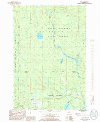
(19)- 1981 Map of Hagerman Lake
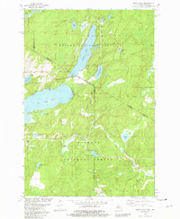
 1981 Hagerman Lake1981 Print · USGSThe Michigan-Wisconsin border comes alive in the early eighties as the Brule River winds through the twin national forests. Researchers can trace the Old Railroad Grade past Bass Lake or explore the settlement of Nelma along the riverbanks.
 - 1981 Map of Smoky Lake
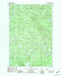
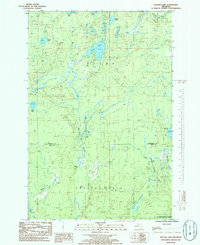
 1981 Smoky Lake1981 Print · USGSThe Michigan-Wisconsin borderlands come into focus in the early 1980s, showcasing a landscape of timber and tourism. You can trace the remote shorelines of Smoky Lake and Big Sand Lake or locate the Phelps Municipal Landing Strip and Elvoy Springs.3 unique versions available
 - 1981 Map of Beechwood
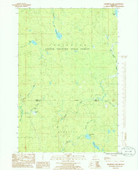
 1981 Beechwood1981 Print · USGSIron County in the early 1980s reveals a landscape of timber and rail where small settlements like Beechwood and Basswood endure. Trace family roots at Rosehill Cem, explore the Chicago and North Western corridor, or locate the Bethany Ch.
 - 1981 Map of Golden Lake, 1982 Print
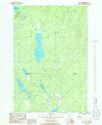
 1981 Golden Lake1982 Print · USGSIron County's timberlands and glacial lakes are captured here in the early 1980s, showcasing a landscape dedicated to forestry and recreation. Researchers can trace the Chicago and North Western rail line through Elmwood or locate the University of Michigan Forestry Camp on Golden Lake.
 - 1982 Map of Lake Mitigwaki, 1983 Print
 1982 Lake Mitigwaki1983 Print · USGSUpper Peninsula wilderness in the early eighties is defined here by the dense hydrology of the Ottawa National Forest. You can trace the Chicago and North Western rail line and locate remote features like Bear Trap Dam and Lake Mitigwaki.
 - 1982 Map of Kenton, 1983 Print
 1982 Kenton1983 Print · USGSUpper Peninsula timber and river lands come into focus during the early eighties, centered on the settlement of Kenton. Researchers can trace the Old RR Grade through the Ottawa National Forest and locate family landmarks like the local Cem or the camps near Tepee Lake.
 - 1982 Map of Winslow Lake, 1983 Print
 1982 Winslow Lake1983 Print · USGSIron County's forested lake country is documented in the early 1980s, centered on the Paint River and its tributaries. Researchers can trace old logging infrastructure at Holmes Dam or locate isolated landmarks like the Big Spring Hole and Winslow Lake.
 - 1982 Map of Glitter Lake, 1983 Print
 1982 Glitter Lake1983 Print · USGSUpper Michigan's lake country is captured here in the early eighties, spanning the wooded border between Houghton and Iron counties. Researchers can trace the water systems of the Ottawa National Forest, from Passmore Springs to remote shores like Glitter Lake and Lake Thirteen.
 - 1985 Map of Drummond Lake, 1986 Print
 1985 Drummond Lake1986 Print · USGSThe Upper Peninsula forestlands at the Baraga and Iron county line come into focus in the mid-1980s, showing a landscape of timber and isolated homesteads. Researchers can locate the precise coordinates of Fox Farm, Drummond Lake, and the remote Copper Country State Forest.
 - 1985 Map of Marten Lake, 1986 Print
 1985 Marten Lake1986 Print · USGSThe Upper Peninsula wilderness near the Houghton and Iron County line is captured here in the mid-1980s. Trace the remote waters of Lake Sainte Kathryn, locate the Roadside Spring by Kunze Lake, and explore the glacial landscape of the Ottawa National Forest.
 - 1985 Map of Ned Lake, 1986 Print
 1985 Ned Lake1986 Print · USGSThe Upper Peninsula wilderness at the border of Baraga and Iron counties is documented here in the mid-eighties, centered on the Copper Country State Forest. Naturalists and locals can trace the intricate waterways of Ned Lake, Shank Lake, and the remote Fence River.
 - 1985 Map of Triangle Ranch, 1986 Print
 1985 Triangle Ranch1986 Print · USGSIron County in the mid-1980s reveals a heavily forested landscape defined by the Hemlock River system and the legacy of the Copper Country. Genealogists and researchers can trace the vicinity of Triangle Ranch, the Railroad line, and Triangle Spur as they appeared forty years ago.
 - 1985 Map of Tunis, 1986 Print
 1985 Tunis1986 Print · USGSUpper Peninsula wilderness in the 1980s is captured here as it straddles the Baraga and Iron County lines. Researchers can trace remote forest outposts like Tunis and Park Siding among the extensive wetlands of Net River Flooding.
 - 1985 Map of Perch Lake, 1986 Print
 1985 Perch Lake1986 Print · USGSIron County’s wooded lake country is captured here in the mid-1980s, centered on the Perch Lake watershed and the Ottawa National Forest. Researchers can trace old family names and small-scale industry across sites like Hannah Webb Lake and a local Gravel Pit.
 - 1985 Map of Porter Lake, 1986 Print
 1985 Porter Lake1986 Print · USGSIron County in the mid-1980s is shown as a dense wilderness of public forests and interconnected waterways. Researchers can trace the path of the Porter River past landmarks like Chipmunk Falls, Snake Rapids, and the shoreline of Porter Lake.
 - 1985 Map of Ned Lake SE, 1986 Print
 1985 Ned Lake SE1986 Print · USGSIron County's northern forests are captured here in the mid-eighties as a landscape defined by timber, water, and legacy industry. You can trace the path of an Old RR Grade and locate remote landmarks such as Camp Eight Ponds and Deer Lake.
 - 1985 Map of Nelson Lake, 1986 Print
 1985 Nelson Lake1986 Print · USGSThe Baraga and Iron county line comes alive in the mid-1980s, showing a remote landscape of Michigan timberland and interior waterways. Trace the courses of the West Branch Michigamme River, identify old water works at Hamilton Dam, and locate the secluded Fence Lake.
 - 1985 Map of Hickman Lake, 1986 Print
 1985 Hickman Lake1986 Print · USGSIron County's timberlands and river networks are captured here in the mid-1980s, revealing a landscape of remote camps and glacial lakes. Researchers can locate Dishaws Camp, trace the Mitchigan River, and find the Swinging Bridge.
 - 1989 Map of Iron River, 1990 Print
 1989 Iron River1990 Print · USGSUpper Peninsula mining and timber lands are documented here in the late 1980s, showcasing the region's industrial and natural interface. Researchers can trace the iron heritage through the Monongahela Mine and local junctions like Kelso Junction and Amasa.
End of results
Showing maps 1-19 of 19
Top cities of Iron County
- Iron River historical maps
- Crystal Falls historical maps
- Caspian historical maps
- Gaastra historical maps
Frequently asked questions
- What are the different types of historical maps available for Iron County?
- What is the oldest map of Iron County?
- Where can I purchase historical maps of Iron County for my home or office?
- Where can I download high-res historical maps of Iron County?
- Are there historical topographic maps available for Iron County?
- Is there historical aerial imagery available for Iron County?
- Where are historical maps of Iron County sourced from?