1900s (20th Century) Maps of Iron River, Michigan
Explore 10 historic maps of Iron River from the 1900s (20th Century). These maps offer a rare glimpse into what life looked like during the 1900s — showing old roads, neighborhoods, homes, and landmarks that have changed or disappeared over time.
Whether you're researching your family's past, planning a metal detecting trip, or studying how Iron River's landscape evolved across the 1900s, these high-resolution maps are a powerful tool for exploring the history of this region.
- Focus on a specific era: All maps on this page are from the 1900s, giving you a focused view of this time period.
- See what’s changed: Compare century-old streets, trails, and buildings to today's modern landscape using overlays and satellite layers.
- Research with precision: Use these maps for genealogy, historical research, land use analysis, or educational projects.
- View, download, or print: Maps are fully viewable online in high resolution, and can be downloaded or printed for your own records.
Start exploring Iron River's history through authentic maps from the 1900s. This is your window into the past.
Iron River, MI maps
(10)- 1944 Map of Iron River, 1956 Print
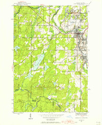 1944 Iron River1956 Print · USGSIron River and the Menominee Range are shown in the 1940s during a peak era of Michigan mining activity. Researchers can trace the extensive rail-and-mine network connecting sites like James Mine, Wauseca Mine, and the Virgil Location worker settlement.2 unique versions available
 - 1944 Map of Gaastra, 1956 Print
 1944 Gaastra1956 Print · USGSIron County thrived during the mid-forties as a critical mining hub where rail lines and company towns shaped the landscape. Genealogists and industrial historians can locate worker housing at Bates Location and trace the paths of the Bates Mine and Bengal Mine.2 unique versions available
 - 1946 Map of Iron River
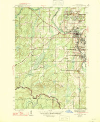 1946 Iron River1946 Print · USGSIron County’s mining heartland is captured here during the mid-1940s, showing the dense industrial corridor from Stambaugh to Caspian. Trace the iron ore legacy through the Hiawatha No 1 Mine and the many worker-housing sites like Homer Location.2 unique versions available
 - 1946 Map of Gaastra
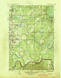 1946 Gaastra1946 Print · USGSIron County’s mining heartland is captured here in the mid-1940s, showing the height of local industrial and community life. Genealogists can locate specific homesteads and family sites near Bates Location, Bates Sch, and the Bengal Mine.
 - 1958 Map of Iron River, 1968 Print
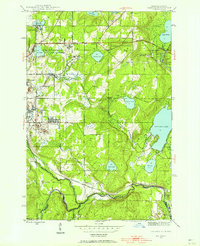
 1958 Iron River1968 Print · USGSThe Upper Peninsula in the late fifties is captured here as a landscape of timber, iron, and rail. Genealogists and historians can trace rail stops like Mass Station or explore the coastlines of Lake Gogebic and Keweenaw Bay.3 unique versions available
 - 1960 Map of Iron River
 1960 Iron River1960 Print · USGSThe Upper Peninsula’s western reaches are shown in the late fifties, featuring the industrial infrastructure of the Copper Country and the vast Ottawa National Forest. Researchers can trace the rail lines of the Milwaukee Road through settlements like Bruce Crossing and the White Pine Mine.
 - 1961 Map of Iron River
 1961 Iron River1961 Print · USGSThe Upper Peninsula and northern Wisconsin are shown here in the early 1960s, a landscape defined by the iron range and vast timberlands. Researchers can trace the legacy of mining and rail transport through Caspian, the Lac Du Flambeau Indian Reservation, and the Milwaukee Road.
 - 1967 Map of Iron River, 1968 Print
 1967 Iron River1968 Print · USGSThe Upper Peninsula and northern Wisconsin borderlands are shown here in the late sixties, a landscape of deep woods and iron-country rail lines. Genealogists and historians can trace the lakeside settlements of L'Anse and Ontonagon or follow the Soo Line through towns like Michigamme and Nestoria.
 - 1989 Map of Iron River, 1990 Print
 1989 Iron River1990 Print · USGSUpper Peninsula mining and timber lands are documented here in the late 1980s, showcasing the region's industrial and natural interface. Researchers can trace the iron heritage through the Monongahela Mine and local junctions like Kelso Junction and Amasa.
 - 1999 Map of Iron River, 2004 Print
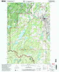 1999 Iron River2004 Print · USGSMining settlements near the Michigan-Wisconsin border come into focus in the late 1990s as these timbered lands were re-surveyed. Genealogists can trace the residential layouts of Homer Location and Forbes Location within this Iron County landscape.
End of results
Showing maps 1-10 of 10
Top cities near Iron River
- Stambaugh historical maps
- Caspian historical maps
- Florence historical maps
- Argonne historical maps
- Gaastra historical maps
- Tipler historical maps
See more
Top neighborhoods of Iron River
- Virgil historical maps
- Hiawatha historical maps
- Homer historical maps
- Mineral Hills historical maps
- Forbes historical maps
- Stambaugh historical maps
Frequently asked questions
- What are the different types of historical maps available for Iron River?
- What is the oldest map of Iron River?
- Where can I purchase historical maps of Iron River for my home or office?
- Where can I download high-res historical maps of Iron River?
- Are there historical topographic maps available for Iron River?
- Is there historical aerial imagery available for Iron River?
- Where are historical maps of Iron River sourced from?