Old Maps of Long Lake, Wisconsin
Explore 13 old maps of Long Lake, spanning from 1939 to today. These high-resolution historic maps reveal how streets, neighborhoods, landmarks, and natural features evolved over time — perfect for genealogy, metal detecting, research, and local history exploration.
What you can do with these maps:
- See how Long Lake changed over time: Compare historical maps to modern-day views to trace roads, homesites, rail lines & more.
- View detailed metadata: Each map includes creators, publishers, year, scale, and archive source.
- Overlay maps with satellite & LiDAR: Visualize the past alongside modern tools to explore terrain & human change.
- Trusted historical sources: Maps sourced from the USGS, Library of Congress, and other archives.
- Access maps your way: View online, download high-res files, or order prints for personal or research use.
Start exploring old maps of Long Lake to uncover forgotten places, hidden landmarks, and the deep history beneath your feet.
Long Lake, WI maps
(13)- 1939 Map of Long Lake, 1957 Print
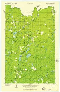 1939 Long Lake1957 Print · USGSNortheastern Wisconsin’s timber country comes alive in this pre-war survey of Florence and Forest counties. Researchers can trace the logging spurs of the Chicago and Northwestern, the Long Lake CCC Camp, and local landmarks like Wild Rose Sch.2 unique versions available
 - 1948 Map of Long Lake
 1948 Long Lake1948 Print · USGSThe timber country of Florence and Forest counties is shown here at the tail end of the New Deal era. You can locate the Long Lake CCC Camp, active logging spurs like Lindels Spur, and several rural schoolhouses including Wild Rose Sch.
 - 1954 Map of Iron Mountain, 1964 Print
 1954 Iron Mountain1964 Print · USGSUpper Michigan and Northeastern Wisconsin are shown in detail during the mid-fifties, when the logging and mining economies still moved by rail. Trace the rail lines of the Soo Line to remote stops like Koepenick Station or explore the Iron Range near Iron Mountain.2 unique versions available
 - 1959 Map of Iron Mountain
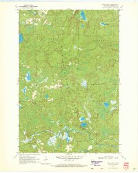
 1959 Iron Mountain1959 Print · USGSThe northwoods of Wisconsin and the Michigan border are captured here in the mid-fifties, showing a landscape defined by timber, water, and rail. Researchers can trace historic junctions like Hiles Junction, the expansive Nicolet National Forest, and lakefront settlements from Rhinelander to Tomahawk.2 unique versions available
 - 1970 Map of Tipler, 1972 Print
 1970 Tipler1972 Print · USGSForest County's timber and lake country is captured here in the early seventies as the rail-and-water economy shaped the landscape. Genealogists and historians can trace the Chicago and North Western line or locate the Martin Cem and Maple Grove Ch.2 unique versions available
 - 1970 Map of Long Lake SE, 1972 Print
 1970 Long Lake SE1972 Print · USGSFlorence County’s lake country appears as a pristine forest landscape during the 1970s. Trace the remote network of wilderness sites like Morgan Lake Campground, the Chapel of St Pius X, and the historic Railroad Grade.2 unique versions available
 - 1970 Map of Long Lake, 1972 Print
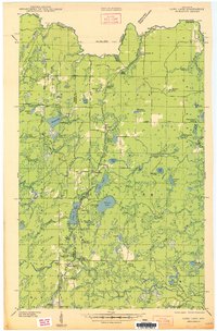
 1970 Long Lake1972 Print · USGSFlorence and Forest Counties are shown in the early seventies, centered on the logging and rail lands of the Nicolet National Forest. You can locate historical landmarks like the Long Lake Lookout Tower, the Townhall, and the Long Lake Cemetery.2 unique versions available
 - 1970 Map of Long Lake NE, 1972 Print
 1970 Long Lake NE1972 Print · USGSFlorence County's border with Michigan was a hub for forestry and recreation during the early seventies. Genealogists and researchers can locate established sites like Lost Lake Campground, the Purdue University Forestry Camp, and Chipmunk Rapids.
 - 1991 Map of Iron Mountain
 1991 Iron Mountain1991 Print · USGSThe Michigan-Wisconsin borderlands appear here in the early nineties, centered on the industrial corridor along the Menominee River. Local researchers can trace the Soo Line through remote timber settlements or locate mining sites like the Bradley Mine and Trader Mine.
 - 2022 Map of Long Lake NE, 2022 Print
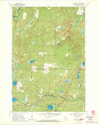
 2022 Long Lake NE2022 Print · USGSThe Wisconsin-Michigan borderlands come into focus in this recent survey of the Florence County wilderness. Genealogists and outdoor historians can trace the legacy of Northwoods recreation and industry through landmarks like Chipmunk Rapids, the Nicolet State Trl, and Lake of Dreams.
 - 2022 Map of Long Lake, 2022 Print
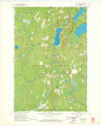
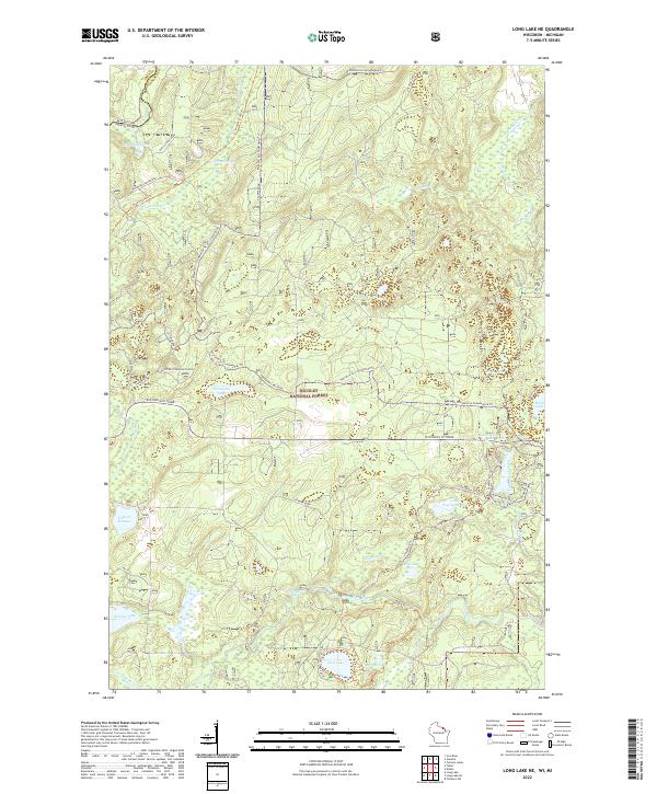
 2022 Long Lake2022 Print · USGSThe Florence County Northwoods are documented here in the early 2020s, showing a landscape defined by timber and water. Genealogists can locate Long Lake Cem and Forest Home Cem among the winding paths of the Nicolet National Forest.
 - 2022 Map of Tipler, 2022 Print
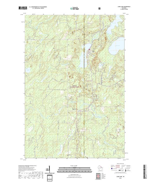
 2022 Tipler2022 Print · USGSThe Northwoods of Wisconsin and Michigan's Upper Peninsula meet in this 2022 study of the Nicolet National Forest. Genealogists and historians can trace the community of Tipler, identifying locations like Tipler Cem and Martin Cem.
 - 2022 Map of Long Lake SE, 2022 Print
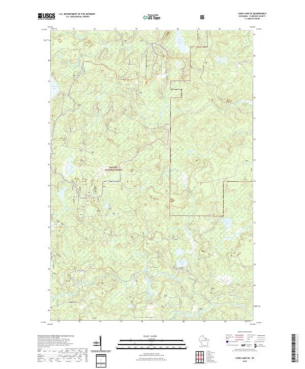 2022 Long Lake SE2022 Print · USGSThe Northwoods of Florence County are defined by their wild river systems and deep forest cover in the early twenty-first century. Outdoorsmen and local historians can trace the paths of the Pine River and Popple River or find secluded spots like Morgan Lake and Lake Seventeen.
End of results
Showing maps 1-13 of 13
Top cities near Long Lake
- Iron River historical maps
- Laona historical maps
- Caspian historical maps
- Goodman historical maps
- Florence historical maps
- Argonne historical maps
See more
Frequently asked questions
- What are the different types of historical maps available for Long Lake?
- What is the oldest map of Long Lake?
- Where can I purchase historical maps of Long Lake for my home or office?
- Where can I download high-res historical maps of Long Lake?
- Are there historical topographic maps available for Long Lake?
- Is there historical aerial imagery available for Long Lake?
- Where are historical maps of Long Lake sourced from?