1910s Maps of Rolland Township, Michigan
Explore 2 historic maps of Rolland Township from the 1910s. These maps offer a rare glimpse into what life looked like during the 1910s — showing old roads, neighborhoods, homes, and landmarks that have changed or disappeared over time.
Whether you're researching your family's past, planning a metal detecting trip, or studying how Rolland Township's landscape evolved across the 1910s, these high-resolution maps are a powerful tool for exploring the history of this region.
- Focus on a specific era: All maps on this page are from the 1910s, giving you a focused view of this time period.
- See what’s changed: Compare century-old streets, trails, and buildings to today's modern landscape using overlays and satellite layers.
- Research with precision: Use these maps for genealogy, historical research, land use analysis, or educational projects.
- View, download, or print: Maps are fully viewable online in high resolution, and can be downloaded or printed for your own records.
Start exploring Rolland Township's history through authentic maps from the 1910s. This is your window into the past.
Rolland Township, MI maps
(2)- 1916 Map of Mount Pleasant
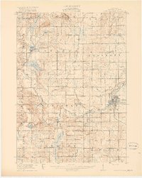 1916 Mount Pleasant1916 Print · USGSIsabella County during the first World War is a landscape of established townships and dense rural school districts. Genealogists and historians can trace the Ann Arbor R.R. through Mount Pleasant or locate old community hubs like Gleaner Hall and Beal City.2 unique versions available
 - 1919 Map of Mount Pleasant
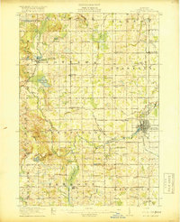 1919 Mount Pleasant1919 Print · USGSIsabella County appears here at its agrarian peak after the Great War, showing a landscape filled with family-named schools and crossroads. Genealogists can trace property proximities to landmarks like Beal City, Rosebush, and the U.S. Indian Industrial School.2 unique versions available
End of results
Showing maps 1-2 of 2
Top cities near Rolland Township
- Mount Pleasant historical maps
- Sumner historical maps
- Stanton historical maps
- Remus historical maps
- Edmore historical maps
- Millbrook historical maps
See more
Top neighborhoods of Rolland Township
Frequently asked questions
- What are the different types of historical maps available for Rolland Township?
- What is the oldest map of Rolland Township?
- Where can I purchase historical maps of Rolland Township for my home or office?
- Where can I download high-res historical maps of Rolland Township?
- Are there historical topographic maps available for Rolland Township?
- Is there historical aerial imagery available for Rolland Township?
- Where are historical maps of Rolland Township sourced from?