
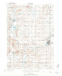
1916 Map of Mount Pleasant
USGS Topo · Published 1916About this map
Mount Pleasant serves as the focal point of this Isabella County landscape, where the Chippewa River winds past the U.S. Indian Industrial School and into the regional trade network. The 1916 survey shows a territory deeply organized around its rural school districts and township halls, with unique landmarks like Mint Mill and Gleaner Hall reflecting the agricultural and social priorities of the time. The rail corridors of the Ann Arbor R.R. and Pere Marquette R.R. connect the outlying settlements of Beal City, Rosebush, and Weidman. Numerous country schools, such as Little Brick School and McDonald School, are spaced throughout the townships, providing a clear map of early twentieth-century education before school consolidation. Water features like Coldwater Lake and the North Branch Chippewa River dictate the placement of early crossings and mills.
Find a feature on this map
84 named features on this map. Tap any name to fly to it.
Don’t see what you’re looking for? This feature index may not catch every label — zoom into the map to look around manually.
Map Details
Editions of this 1916 Mount Pleasant Map
2 editions found
Other maps of this area

1919 · Mount Pleasant
USGS Topo · 1:62,500

1930 · Shepherd
USGS Topo · 1:48,000

1935 · Alma
USGS Topo · 1:62,500

1936 · Shepherd
USGS Topo · 1:62,500

1938 · Alma
USGS Topo · 1:62,500

1943 · Mount Pleasant
USGS Topo · 1:62,500

1954 · Midland
USGS Topo · 1:250,000

1958 · Midland
USGS Topo · 1:250,000

1959 · Midland
USGS Topo · 1:250,000

1959 · Lake
USGS Topo · 1:62,500