
Loading...
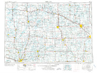
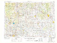
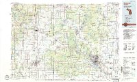
Loading map...1954 Map of Midland
USGS Topo · Published 1967About this map
The Muskegon and Tittabawassee river systems anchor this mid-Michigan landscape during a period of steady post-war expansion. While industrial centers like Midland and Saginaw dominate the eastern reaches, the western portion is defined by the heavy timberlands of the Manistee National Forest and Pere Marquette State Forest. A complex network of transport connects these hubs, including the Pennsylvania RR and Chesapeake and Ohio RR, alongside early state routes like M 20 and M 46.
Find a feature on this map
139 named features on this map. Tap any name to fly to it.
Don’t see what you’re looking for? This feature index may not catch every label — zoom into the map to look around manually.
Map Details
Date Portrayed1954
Date Published1967
PublisherU.S. Geological Survey
Map TypeTopographic
Scale1:250,000
Physical Dimensions29.3 x 22.1 inches
Editions of this 1954 Midland Map
4 editions found

Historical Maps of Grand Rapids Through Time
5 maps found


Featured Locations
Source Details
SourceU.S. Geological Survey
CopyrightPublic Domain