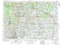
1954 Map of Midland
USGS Topo · Published 1984About this map
Midland and Saginaw anchor the eastern industrial corridor of this mid-Michigan landscape, a region defined by its intersecting river systems and extensive state-managed woodlands. The map traces the convergence of the Tittabawassee River and the Saginaw River, where manufacturing centers like Alma, St Louis, and Midland grew alongside significant water resources. To the west, the Muskegon River winds through Big Rapids and the Manistee National Forest, illustrating a sharp transition from the fertile river valleys of the south to the timber-rich northern highlands.
Find a feature on this map
99 named features on this map. Tap any name to fly to it.
Don’t see what you’re looking for? This feature index may not catch every label — zoom into the map to look around manually.
Map Details
Editions of this 1954 Midland Map
4 editions found

Other maps of this area

1914 · Grand Rapids
USGS Topo · 1:62,500

1916 · Bay City
USGS Topo · 1:62,500

1916 · Mount Pleasant
USGS Topo · 1:62,500

1916 · Ionia
USGS Topo · 1:62,500

1917 · Chesaning
USGS Topo · 1:62,500

1917 · St. Charles
USGS Topo · 1:62,500

1918 · Cedar Springs
USGS Topo · 1:62,500

1918 · Elsie
USGS Topo · 1:62,500

1918 · Ionia
USGS Topo · 1:62,500

1918 · Perrinton
USGS Topo · 1:62,500