
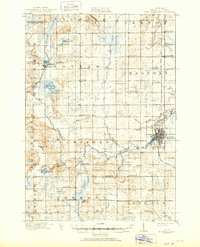
1919 Map of Mount Pleasant
USGS Topo · Published 1919About this map
Mount Pleasant serves as the focal point of this 1919 study, where the Ann Arbor RR and the Chippewa River converge. The landscape is defined by a dense grid of rural schoolhouses and small crossroads settlements, reflecting a peak era of agrarian development in Isabella County. Significant landmarks such as the U.S. Indian Industrial School and the Indian Church are documented alongside established townships like Nottawa and Isabella.
Find a feature on this map
85 named features on this map. Tap any name to fly to it.
Don’t see what you’re looking for? This feature index may not catch every label — zoom into the map to look around manually.
Map Details
Editions of this 1919 Mount Pleasant Map
2 editions found
Other maps of this area

1916 · Mount Pleasant
USGS Topo · 1:62,500

1930 · Shepherd
USGS Topo · 1:48,000

1935 · Alma
USGS Topo · 1:62,500

1936 · Shepherd
USGS Topo · 1:62,500

1938 · Alma
USGS Topo · 1:62,500

1943 · Mount Pleasant
USGS Topo · 1:62,500

1954 · Midland
USGS Topo · 1:250,000

1958 · Midland
USGS Topo · 1:250,000

1959 · Midland
USGS Topo · 1:250,000

1959 · Lake
USGS Topo · 1:62,500