
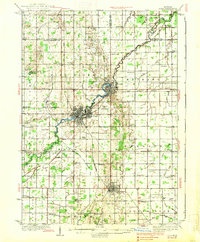
1938 Map of Alma
USGS Topo · Published 1938About this map
The Pine River dictates the layout of the central Michigan landscape in this mid-1930s survey, winding between the burgeoning industrial and residential centers of Alma and St Louis. This area of Gratiot County shows a dense network of rural infrastructure, where nearly every section corner is anchored by a named schoolhouse, such as Jack Day Sch or Pleasant View Sch. The transportation corridor is defined by the crossing of the Ann Arbor and Pere Marquette railroads, which facilitated the movement of goods through the region's agricultural heartland.
Find a feature on this map
86 named features on this map. Tap any name to fly to it.
Don’t see what you’re looking for? This feature index may not catch every label — zoom into the map to look around manually.
Map Details
Editions of this 1938 Alma Map
2 editions found
Other maps of this area

1916 · Mount Pleasant
USGS Topo · 1:62,500

1918 · Elsie
USGS Topo · 1:62,500

1918 · Perrinton
USGS Topo · 1:62,500

1919 · Mount Pleasant
USGS Topo · 1:62,500

1930 · Shepherd
USGS Topo · 1:48,000

1934 · Sanford
USGS Topo · 1:62,500

1934 · Merrill
USGS Topo · 1:62,500

1935 · Alma
USGS Topo · 1:62,500

1936 · Shepherd
USGS Topo · 1:62,500

1936 · Sanford
USGS Topo · 1:62,500