1980s Maps of Jackson County, Michigan
Explore 11 historic maps of Jackson County from the 1980s. These maps offer a rare glimpse into what life looked like during the 1980s — showing old roads, neighborhoods, homes, and landmarks that have changed or disappeared over time.
Whether you're researching your family's past, planning a metal detecting trip, or studying how Jackson County's landscape evolved across the 1980s, these high-resolution maps are a powerful tool for exploring the history of this region.
- Focus on a specific era: All maps on this page are from the 1980s, giving you a focused view of this time period.
- See what’s changed: Compare century-old streets, trails, and buildings to today's modern landscape using overlays and satellite layers.
- Research with precision: Use these maps for genealogy, historical research, land use analysis, or educational projects.
- View, download, or print: Maps are fully viewable online in high resolution, and can be downloaded or printed for your own records.
Start exploring Jackson County's history through authentic maps from the 1980s. This is your window into the past.
Jackson County, MI maps
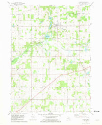
(11)- 1980 Map of Norvell, 1981 Print
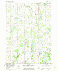
 1980 Norvell1981 Print · USGSThe Jackson County countryside during the late seventies reveals a landscape of lakeside retreats and small-town junctions. Genealogists and local historians can trace family locations near Napoleon, Norvell, and rural landmarks like Long School and Maple Grove Cem.2 unique versions available
 - 1980 Map of Onsted, 1981 Print
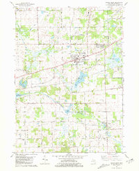
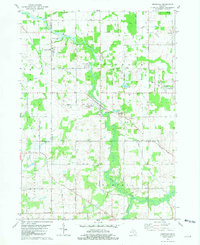
 1980 Onsted1981 Print · USGSThe Irish Hills region in the early eighties was a bustling hub of lakefront recreation and automotive racing. Genealogists and local historians can locate Maple Shade Cem, the landmark St Joseph Shrine, and old routes through Brooklyn and Onsted.2 unique versions available
 - 1981 Map of Spring Arbor
 1981 Spring Arbor1981 Print · USGSJackson County in the late seventies is captured here, showing the growth of Spring Arbor and Horton. Genealogists and historians can trace local landmarks like Luttenton Cemetery, Western High School, and the CONRAIL corridor.
 - 1981 Map of Southeast Albion
 1981 Southeast Albion1981 Print · USGSThe rural landscape between Albion and Concord is captured here in the early 1980s, revealing a network of river-fed townships. Genealogists can locate family sites at Maple Grove Cemetery and West Brick Cem, or trace the winding course of the Kalamazoo River.
 - 1981 Map of Hanover
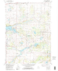
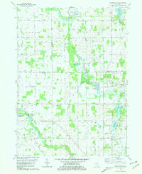
 1981 Hanover1981 Print · USGSThe Jackson and Hillsdale county line comes alive in the early eighties, showing a landscape of glacial lakes and developing energy infrastructure. Genealogists can trace family roots through numerous sites like McNair Cem, the Moscow Plains Ch, and the settlement of Mosherville Station.
 - 1981 Map of Onondaga
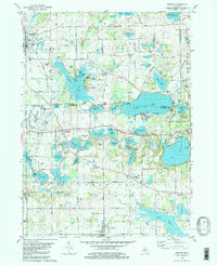
 1981 Onondaga1981 Print · USGSMid-Michigan rural life in the early eighties centers on the river and rail lines connecting Ingham and Jackson counties. Local historians can trace family markers at Brown Cem and Lane Cem or explore the grounds of the VFW National Home.
 - 1981 Map of Mosherville
 1981 Mosherville1981 Print · USGSSouthern Michigan farm country in the early eighties shows a landscape of river headwaters and small crossroads settlements at the junction of three counties. Genealogists can locate several family-named burial grounds like Mount Hope Cem and Buck Cem, or trace the old Railroad Grade near Mosherville.
 - 1981 Map of Parma
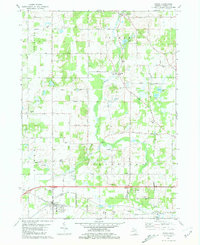 1981 Parma1981 Print · USGSParma and its surrounding townships in the early 1980s show a settled landscape of rail lines and small family cemeteries. Genealogists can locate several burial sites like Pherdun Cem and Deering Cem, or trace the path of the Conrail through town.
 - 1981 Map of Springport
 1981 Springport1981 Print · USGSMid-Michigan's landscape in the early eighties shows a transition from the industrial activity of Eaton Rapids to the quiet rural corners of Springport. Genealogists and historians can trace family sites at Rose Hill Cem or follow the Conrail tracks through Charlesworth.
 - 1981 Map of Northeast Albion
 1981 Northeast Albion1981 Print · USGSThe rural borderlands of Jackson and Calhoun counties come alive in this early 1980s record of Michigan's farming and small-town heartland. Genealogists and local historians can trace the foundations of Springport and Devereaux while locating family plots at Quakertown Cem or Wright Cem.2 unique versions available
 - 1983 Map of Jackson, 1984 Print
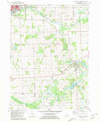
 1983 Jackson1984 Print · USGSJackson and the surrounding lake country are shown in the early eighties as a hub of rail transit and outdoor recreation. Local historians can trace institutional footprints like the State Prison Farm or explore the landscape of Minards Mill and Olivet College.
End of results
Showing maps 1-11 of 11
Top cities of Jackson County
Frequently asked questions
- What are the different types of historical maps available for Jackson County?
- What is the oldest map of Jackson County?
- Where can I purchase historical maps of Jackson County for my home or office?
- Where can I download high-res historical maps of Jackson County?
- Are there historical topographic maps available for Jackson County?
- Is there historical aerial imagery available for Jackson County?
- Where are historical maps of Jackson County sourced from?