1970s Maps of Jefferson, Columbia Township
Explore 1 historic maps of Jefferson from the 1970s. These maps offer a rare glimpse into what life looked like during the 1970s — showing old roads, neighborhoods, homes, and landmarks that have changed or disappeared over time.
Whether you're researching your family's past, planning a metal detecting trip, or studying how Jefferson's landscape evolved across the 1970s, these high-resolution maps are a powerful tool for exploring the history of this region.
- Focus on a specific era: All maps on this page are from the 1970s, giving you a focused view of this time period.
- See what’s changed: Compare century-old streets, trails, and buildings to today's modern landscape using overlays and satellite layers.
- Research with precision: Use these maps for genealogy, historical research, land use analysis, or educational projects.
- View, download, or print: Maps are fully viewable online in high resolution, and can be downloaded or printed for your own records.
Start exploring Jefferson's history through authentic maps from the 1970s. This is your window into the past.
Jefferson, Columbia Township maps
(1)- 1971 Map of Cement City, 1973 Print
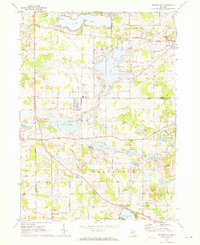 1971 Cement City1973 Print · USGSThe Irish Hills region in the early seventies shows a community balanced between traditional rail-side industry and growing lakeside recreation. Trace family roots at Sanford Cem, locate the old Penn Central tracks, or find long-standing landmarks like St Rita Ch.2 unique versions available
End of results
Showing maps 1-1 of 1
Top cities near Jefferson
- Jackson historical maps
- Adrian historical maps
- Leoni historical maps
- Spring Arbor Township historical maps
- Napoleon historical maps
- Vandercook Lake historical maps
See more
Frequently asked questions
- What are the different types of historical maps available for Jefferson?
- What is the oldest map of Jefferson?
- Where can I purchase historical maps of Jefferson for my home or office?
- Where can I download high-res historical maps of Jefferson?
- Are there historical topographic maps available for Jefferson?
- Is there historical aerial imagery available for Jefferson?
- Where are historical maps of Jefferson sourced from?