1970s Maps of Waterloo Township, Michigan
Explore 4 historic maps of Waterloo Township from the 1970s. These maps offer a rare glimpse into what life looked like during the 1970s — showing old roads, neighborhoods, homes, and landmarks that have changed or disappeared over time.
Whether you're researching your family's past, planning a metal detecting trip, or studying how Waterloo Township's landscape evolved across the 1970s, these high-resolution maps are a powerful tool for exploring the history of this region.
- Focus on a specific era: All maps on this page are from the 1970s, giving you a focused view of this time period.
- See what’s changed: Compare century-old streets, trails, and buildings to today's modern landscape using overlays and satellite layers.
- Research with precision: Use these maps for genealogy, historical research, land use analysis, or educational projects.
- View, download, or print: Maps are fully viewable online in high resolution, and can be downloaded or printed for your own records.
Start exploring Waterloo Township's history through authentic maps from the 1970s. This is your window into the past.
Waterloo Township, MI maps
(4)- 1970 Map of Munith, 1972 Print
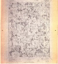 1970 Munith1972 Print · USGSIngham and Jackson counties meet in this 1970s record of rural Michigan, showing the agricultural and lakeside communities before significant modern expansion. Genealogists can trace family footprints through historic burial grounds like Bunker Hill Cemetery and the rail-side settlement of Munith along the Grand Trunk Western line.3 unique versions available
 - 1970 Map of Gilletts Lake, 1973 Print
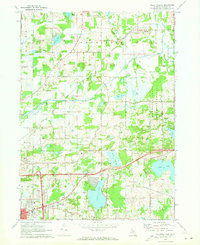 1970 Gilletts Lake1973 Print · USGSJackson County's landscape east of the city is captured here in the early 1970s, showing a blend of institutional land and growing lakeside communities. Trace historic footprints at the State Prison Farm, Henrietta Station, and old family burial grounds like Coon Hill Cem.2 unique versions available
 - 1973 Map of Grass Lake, 1977 Print
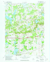 1973 Grass Lake1977 Print · USGSJackson County is shown in the early seventies, a landscape defined by the expansive glacial wetlands and lakes of the Waterloo State Recreation Area. Researchers can trace old family sites and rural landmarks like Mt Hope Cem, the Trist Millpond, and the settlement of Francisco.2 unique versions available
 - 1973 Map of Stockbridge, 1977 Print
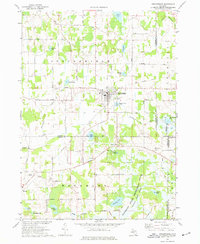 1973 Stockbridge1977 Print · USGSStockbridge and its glacial lake surroundings are captured here in the early seventies, spanning the borders of Ingham, Livingston, and Jackson Counties. Genealogists and local historians can locate several family-named landmarks and rural burial grounds such as Oaklawn Cem, Munith Cem, and the Old Railroad Grade.
End of results
Showing maps 1-4 of 4
Top cities near Waterloo Township
- Jackson historical maps
- Leoni historical maps
- Marion Township historical maps
- Putnam Township historical maps
- Mason historical maps
- Napoleon historical maps
See more
Top neighborhoods of Waterloo Township
Frequently asked questions
- What are the different types of historical maps available for Waterloo Township?
- What is the oldest map of Waterloo Township?
- Where can I purchase historical maps of Waterloo Township for my home or office?
- Where can I download high-res historical maps of Waterloo Township?
- Are there historical topographic maps available for Waterloo Township?
- Is there historical aerial imagery available for Waterloo Township?
- Where are historical maps of Waterloo Township sourced from?