1990s Maps of Kalamazoo County, Michigan
Explore 2 historic maps of Kalamazoo County from the 1990s. These maps offer a rare glimpse into what life looked like during the 1990s — showing old roads, neighborhoods, homes, and landmarks that have changed or disappeared over time.
Whether you're researching your family's past, planning a metal detecting trip, or studying how Kalamazoo County's landscape evolved across the 1990s, these high-resolution maps are a powerful tool for exploring the history of this region.
- Focus on a specific era: All maps on this page are from the 1990s, giving you a focused view of this time period.
- See what’s changed: Compare century-old streets, trails, and buildings to today's modern landscape using overlays and satellite layers.
- Research with precision: Use these maps for genealogy, historical research, land use analysis, or educational projects.
- View, download, or print: Maps are fully viewable online in high resolution, and can be downloaded or printed for your own records.
Start exploring Kalamazoo County's history through authentic maps from the 1990s. This is your window into the past.
Kalamazoo County, MI maps
(2)- 1995 Map of Kalamazoo, 1999 Print
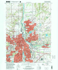 1995 Kalamazoo1999 Print · USGSKalamazoo and its industrial suburbs are captured in the mid-nineties as the city center thrives alongside the river and rail lines. Researchers can map out institutional history at Western Michigan University and trace family roots at Mt Olivet Cemetery or Mountain Home Cem.
 - 1998 Map of Augusta, 1999 Print
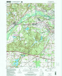 1998 Augusta1999 Print · USGSThe river valleys of the Kalamazoo and Battle Creek come alive in the late nineties, showcasing a unique mix of military legacies and conservation. Genealogists and historians can trace the grounds of Fort Custer National Cemetery or locate the historic Martin Sch and Lawler Cem.
End of results
Showing maps 1-2 of 2
Top cities of Kalamazoo County
Frequently asked questions
- What are the different types of historical maps available for Kalamazoo County?
- What is the oldest map of Kalamazoo County?
- Where can I purchase historical maps of Kalamazoo County for my home or office?
- Where can I download high-res historical maps of Kalamazoo County?
- Are there historical topographic maps available for Kalamazoo County?
- Is there historical aerial imagery available for Kalamazoo County?
- Where are historical maps of Kalamazoo County sourced from?