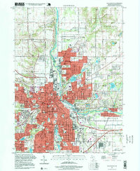
1995 Map of Kalamazoo
USGS Topo · Published 1999About this map
The Kalamazoo River anchors this mid-1990s landscape, winding northward between the industrial and institutional centers of Kalamazoo and Parchment. The map reveals a densely organized urban core featuring significant landmarks like Western Michigan University, Kalamazoo College, and the sprawling grounds of the Kalamazoo State Hospital. To the north, the terrain shifts into a mosaic of gravel pits and the lush Kalamazoo Nature Center, illustrating the transition from city industry to protected environmental spaces.
Find a feature on this map
94 named features on this map. Tap any name to fly to it.
Don’t see what you’re looking for? This feature index may not catch every label — zoom into the map to look around manually.
Map Details
Editions of this 1995 Kalamazoo Map
This is the sole edition of this map. No revisions or reprints were ever made.
Other maps of this area

1916 · Kalamazoo
USGS Topo · 1:62,500

1918 · Kalamazoo
USGS Topo · 1:62,500

1918 · Galesburg
USGS Topo · 1:62,500

1918 · Leonidas
USGS Topo · 1:62,500

1922 · Schoolcraft
USGS Topo · 1:62,500

1943 · Kalamazoo
USGS Topo · 1:62,500

1943 · Schoolcraft
USGS Topo · 1:62,500

1944 · Leonidas
USGS Topo · 1:62,500

1944 · Galesburg
USGS Topo · 1:62,500

1947 · Delton
USGS Topo · 1:24,000
Featured Places
- Kalamazoo, MI
- Parchment, MI
- Comstock Charter Township, MI
- Kalamazoo Charter Township, MI
- Richland Township, MI