1910s Maps of Ross Township, Michigan
Explore 1 historic maps of Ross Township from the 1910s. These maps offer a rare glimpse into what life looked like during the 1910s — showing old roads, neighborhoods, homes, and landmarks that have changed or disappeared over time.
Whether you're researching your family's past, planning a metal detecting trip, or studying how Ross Township's landscape evolved across the 1910s, these high-resolution maps are a powerful tool for exploring the history of this region.
- Focus on a specific era: All maps on this page are from the 1910s, giving you a focused view of this time period.
- See what’s changed: Compare century-old streets, trails, and buildings to today's modern landscape using overlays and satellite layers.
- Research with precision: Use these maps for genealogy, historical research, land use analysis, or educational projects.
- View, download, or print: Maps are fully viewable online in high resolution, and can be downloaded or printed for your own records.
Start exploring Ross Township's history through authentic maps from the 1910s. This is your window into the past.
Ross Township, MI maps
(1)- 1918 Map of Galesburg
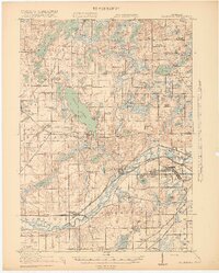 1918 Galesburg1918 Print · USGSKalamazoo and Barry Counties appear during the First World War, showing a landscape defined by the massive Camp Custer military reservation. Researchers can trace rural life through a network of dozens of one-room schoolhouses, the Michigan Central rail line, and summer colonies on Gull Lake.5 unique versions available
End of results
Showing maps 1-1 of 1
Top cities near Ross Township
- Kalamazoo historical maps
- Battle Creek historical maps
- Portage historical maps
- Pavilion historical maps
- Springfield historical maps
- Prairieville historical maps
See more
Top neighborhoods of Ross Township
- Midland Park historical maps
- South Gull Lake historical maps
- Island Park historical maps
- Yorkville historical maps
- Gull Lake historical maps
- Howlandsburg historical maps
See more
Frequently asked questions
- What are the different types of historical maps available for Ross Township?
- What is the oldest map of Ross Township?
- Where can I purchase historical maps of Ross Township for my home or office?
- Where can I download high-res historical maps of Ross Township?
- Are there historical topographic maps available for Ross Township?
- Is there historical aerial imagery available for Ross Township?
- Where are historical maps of Ross Township sourced from?